


Wintry precipitation possible later today, then changing to rain tonight. Much warmer later in the week.
From
To


It's noticeably colder today behind a cold front, with an increasing northerly breeze, with sun and clouds.


High pressure continues to move offshore this evening, as southerly winds pull in warmer air, allowing afternoon highs to reach the mid to upper 60s this weekend. We'll see a better chance of showers Sunday. Then a taste of winter early next week.

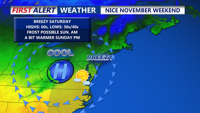
The wicked winds we saw on Halloween will decrease into the weekend with lots of sunshine expected.


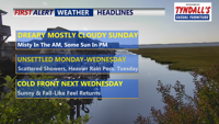
We're expecting a cool and somewhat cloudy end to the weekend, with increasing rain chances midweek.

Another round of patchy frost is possible Sunday morning, with a cool and somewhat cloudy end to the weekend.

DELMARVA- A few scattered showers may linger early this afternoon, especially near the coast. Gusty northwest winds will develop this afternoo…

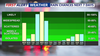
Much needed rain is heading for Delmarva through the midweek time period. A code red is in effect for Wednesday for rain heavy at times and gusty winds.

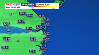
Delmarva will see clearing skies on Monday following a frontal passage, with mild temperatures and a light breeze. High pressure will maintain calm and dry weather Monday night into Tuesday morning, though some light showers could develop by late Tuesday night as a warm front approaches.

Delmarva will experience a continuation of muggy conditions tonight with areas of fog and temperatures dipping into the mid to upper 60s. The unsettled weather pattern will persist through midweek as an upper-level low and several shortwaves bring scattered showers to the region. Coastal low pressure could develop off the coast, leading to more moderate showers by Monday night into Tuesday. A cold front is expected to move through by Wednesday, followed by drier and more stable conditions towards the end of the week.