


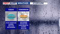
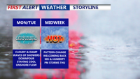
A gloomy, damp day continues across Delmarva with highs in the upper 40s to low 50s inland. Scattered showers and drizzle develop this evening and overnight with patchy fog and lows in the mid to upper 40s. Temperatures trend much warmer midweek into early next week (10–20° above average), though a back-and-forth front late week could create sharp north/south temperature differences and several chances for showers—plus a small thunder risk Thursday night.
From
To

Delmarva begins the week with damp, gray skies and cooler temperatures, but change is on the horizon. After periods of drizzle and light showers Monday and Tuesday, warmer and more humid air arrives midweek. By Thursday, temperatures could soar into the 90s with strong to severe storms possible as a cold front sweeps through. The weekend looks drier and more comfortable with sunshine and highs in the 80s.

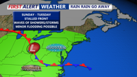
Unsettled conditions continue Sunday afternoon with continued clouds, cool temperatures, and scattered showers. A stalled front will keep the region damp through Tuesday before a warm front ushers in summerlike conditions midweek. Thursday brings a risk of severe storms followed by improving weather for the weekend.

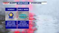
Clouds, cool temperatures, and the chance of scattered showers will dominate Delmarva’s Father’s Day forecast as a stalled front lingers near the region. Unsettled conditions will continue into early next week before a midweek warm-up sets the stage for possible severe storms Thursday. A return to sunny, dry weather is expected by Friday.


Delmarva starts the week with marine clouds and patchy fog as an onshore flow keeps skies gray and temperatures mild. A cold front will bring showers and a low-end severe threat Tuesday before high pressure brings sunshine and near 90-degree warmth by midweek. Rain chances return by the weekend as another front approaches.

While severe storms remain west and south of the region, Delmarva starts the week under persistent cloud cover, patchy fog, and a low-end risk of isolated storms as a cold front approaches. Warmer, sunnier days are on the horizon by midweek.

Sunday afternoon brings sunshine, cool temperatures, and breezy west winds across Delmarva. High pressure will dominate the region into midweek, leading to gradually warmer days and a potential return of summer heat by Thursday.

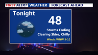
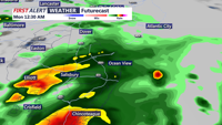
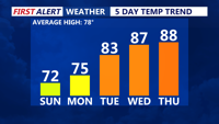
Storms have come to an end, clear and chilly night on tap as some areas away from the coast fall into the 40s. Bright, beautiful, breezy end to the weekend, summer-like next week as we make a run at our first 90 degree day of the year.

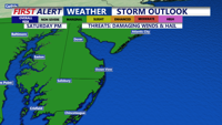
Showers and possible thunderstorms Saturday afternoon and evening, with the chance for strong wind gusts, hail and localized flooding. Conditions improve by Sunday, ushering in a stretch of dry and warmer weather through midweek, with summer-like temperatures returning by Wednesday.

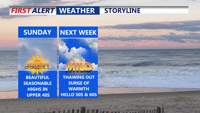
The Delmarva peninsula is set for a stunning end to the weekend as seasonable temperatures return on Sunday with highs in the upper 40s. High pressure dominates into early next week, ushering in a gradual warming trend. While Sunday night will be chilly with temperatures dipping into the 20s, Monday promises a rebound into the 50s and Tuesday could see highs rising into the low 60s. A weak cold front is expected late Tuesday, with a stronger one arriving on Thursday, though precipitation remains minimal and fair weather is forecast to prevail later in the week.