


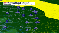
Low pressure slides to our south late Sunday into early Monday morning bringing a soaking rain.
From
To


The dangerous cold stretch continues for Delmarva for the rest of the weekend and into the start of the new week.

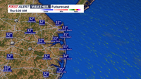
A fast moving system will bring a cold rain to our region with tricky travel farther north with ice and snow.


A cold front will slide southeast through the region this evening, but it’s expected to pass without rain and with little added cloud cover. The main change will be a noticeable uptick in winds and a refreshing push of cooler air.


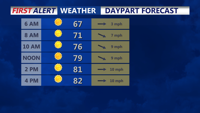
Expect a stretch of mild, mostly dry weather through the weekend as high pressure remains the dominant feature over the region.


DELMARVA -- A strong area of Canadian high pressure centered near Hudson Bay is gradually pushing south through the Great Lakes into the Mid-A…

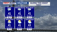
Colder air is settling into the region this afternoon, with highs only reaching the mid 50s. It will be breezy with gusts up to 30 mph at times.

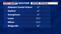
Sussex county got walloped with snow yesterday. Here's a list of the snow totals from Monday's storm.


We're locked into a cold pattern across Delmarva for the rest of the week. Temperatures do warm gradually for the week ahead, then drop again by Friday into the weekend. Some rain and lots of wind for Thursday, and possible snowflakes.

Monday night, the initial cold front will pass through the region, followed by a secondary front on Tuesday, bringing a significant drop in humidity but little change in temperature, with Delmarva, Coastal Sussex County, Ocean City, and Cambridge experiencing much drier conditions.