


Delmarva will see one more hot and humid day today, with inland highs in the mid 90s and a third straight 90-degree day marking a heat wave. A strong cold front will bring showers and isolated severe thunderstorms late this afternoon and evening, followed by a much cooler, unsettled pattern through the end of the week and Memorial Day weekend.
From
To

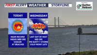
Delmarva will stay hot, sunny and dry today as southwest winds continue to push early-season heat into the region. Georgetown could approach or break a daily record high, while Delaware beaches will remain cooler but breezy. A Code Orange Air Quality Alert is in effect for Delaware today through Wednesday, and there is a moderate risk of dangerous rip currents at Delaware beaches. One more very hot day is expected Wednesday before a cold front brings showers and thunderstorms, with isolated strong to severe storms possible. Cooler, unsettled weather is expected late week into Memorial Day weekend.


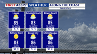
Strong to severe storms, damaging wind gusts, minor bay flooding and rough marine conditions are expected from late Monday evening into late Tuesday evening in Sussex County and along the Delaware and Maryland beaches.

High pressure keeps Sussex County dry through Thursday, but dangerous heat and the chance of severe storms arrive Friday as a cold front approaches.


A tropical air mass and slow-moving front will keep daily rounds of thunderstorms and warm, muggy nights in place through early Friday.

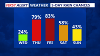
Severe storms, heavy rain and tropical humidity will persist through late Thursday evening as a slow-moving front wobbles across the region.

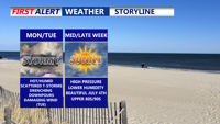
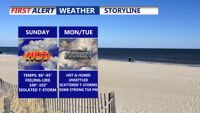
Sunday brought oppressive heat and humidity fueled strong thunderstorms across Sussex County. Flash flooding quickly inundated coastal communities, while a microburst near Laurel generated wind gusts nearing 60 mph. Additional rounds of storms are expected Monday and Tuesday, with a heightened risk of damaging winds and flooding.

A weak cold front moving into Delmarva Saturday night will stall and keep unsettled conditions through early next week. After a hot and humid Sunday, a warm front lifting north Monday will bring scattered storms and sweltering heat indices above 100 degrees inland. By Tuesday, a stronger cold front could trigger severe thunderstorms with damaging winds. Drier, more comfortable weather gradually arrives mid to late week, just in time for the Fourth of July weekend.


After a dramatic drop in temperatures Friday, Delmarva will swing back into heat and humidity over the weekend. A warm front lifting north will send temperatures soaring into the 90s Saturday, with heat indices over 100 degrees in spots. A weak cold front will briefly stall Sunday before more unsettled weather arrives early next week.

Strong storms and a cold front Thursday evening will offer a brief break from the heat, but Sussex County will see rising temperatures and humidity again through the weekend into next week.