


DELMARVA -- A weak cold front is sliding southeast across Delmarva Saturday evening, bringing lingering showers that should taper off around midnight. The front won’t fully clear the region, instead stalling over the area and creating pockets of patchy mist and fog overnight, especially where rainfall has occurred. Overnight temperatures will remain warm, with lows in the mid-70s.
Sunday will start with any fog quickly dissipating. Much of northern Delmarva can expect mostly sunny skies, while southern areas near the stalled boundary see more clouds and a chance of isolated to scattered showers or thunderstorms, especially during the afternoon.

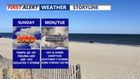
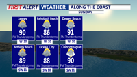
Highs in the upper 80s to low 90s, pop-up afternoon storms possible. Moderate risk of rip currents.
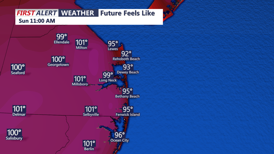
High temperatures will climb into the upper 80s and low 90s, with heat index values soaring between 100 and 104 degrees inland—creating oppressive conditions for outdoor plans.

Once again we could see some areas away from the coast feel like 100 to 104.
Sunday night stays warm and muggy, with lows ranging from the mid-60s north to the low 70s south. A few showers may linger across southern Delmarva.

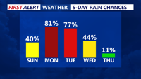
Staying unsettled the next 3 days, scattered showers and storms Monday and Tuesday.
On Monday, a warm front lifting north will increase moisture and instability. Scattered showers and thunderstorms are possible, especially in southern and western parts of the peninsula. Highs will again approach 90 degrees, and dew points in the 70s will make it feel even hotter. Muggy conditions continue Monday night, with lows holding in the 70s.
Tuesday is the day to watch closely: an upper-level trough swinging across the Northeast will help drive a stronger cold front toward the region. As temperatures warm into the mid-to-upper 80s and humidity remains high, moderate instability could overlap with increasing wind shear—raising the risk for severe thunderstorms capable of damaging winds during the afternoon and early evening.
By Tuesday night, the cold front is forecast to push offshore, ending showers and storms by around midnight. Lows will slip a bit cooler, into the upper 60s and low 70s.
Wednesday and Thursday will feel more comfortable, with lower humidity and drier air settling in as high pressure builds over the Mid-Atlantic. Despite the lingering upper-level trough overhead, rain chances look minimal, and highs will remain in the upper 80s.
By Friday and into the July Fourth holiday weekend, high pressure becomes more established across Delmarva, providing mostly dry weather with seasonable warmth and dew points in the 60s. Overall, the forecast looks favorable for holiday plans across the region.