


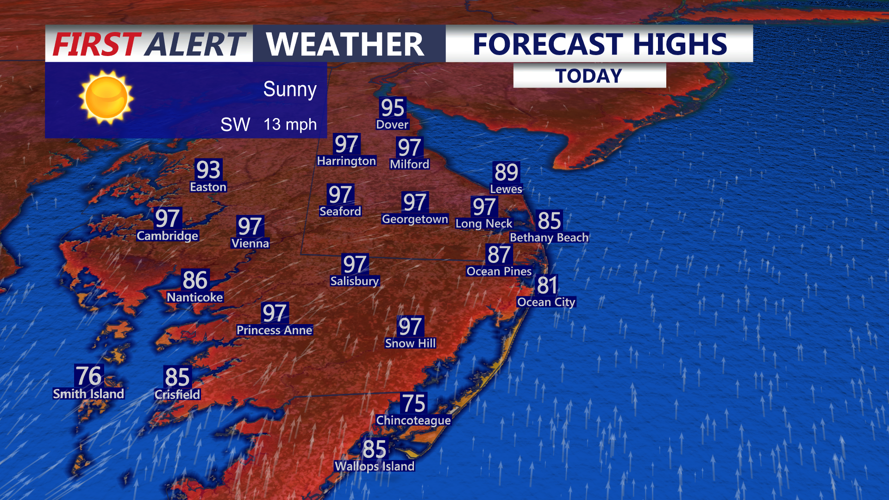


DELMARVA -- The peninsula will remain under a stretch of early-season heat today as a strong upper-level ridge off the Southeast coast and high pressure over the western Atlantic continue to drive a south to southwest flow across the region.

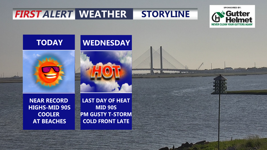
Another day of record highs are likely in Georgetown, cooler at the coast in the 80s.
Sunny, hot and dry conditions are expected today, with inland highs near the upper 90s. Georgetown is forecast to reach around 97 degrees, which would come close to or exceed the daily record of 96 degrees set in 1962. Georgetown already reached record heat yesterday, and today’s temperatures may again challenge historic levels. The warmest May temperature on record in Georgetown is 98 degrees, set on May 28, 1991.
At the Delaware beaches, temperatures will be cooler but still warm, generally in the mid to upper 80s. Southwest winds may gust between 20 and 30 mph through the day.
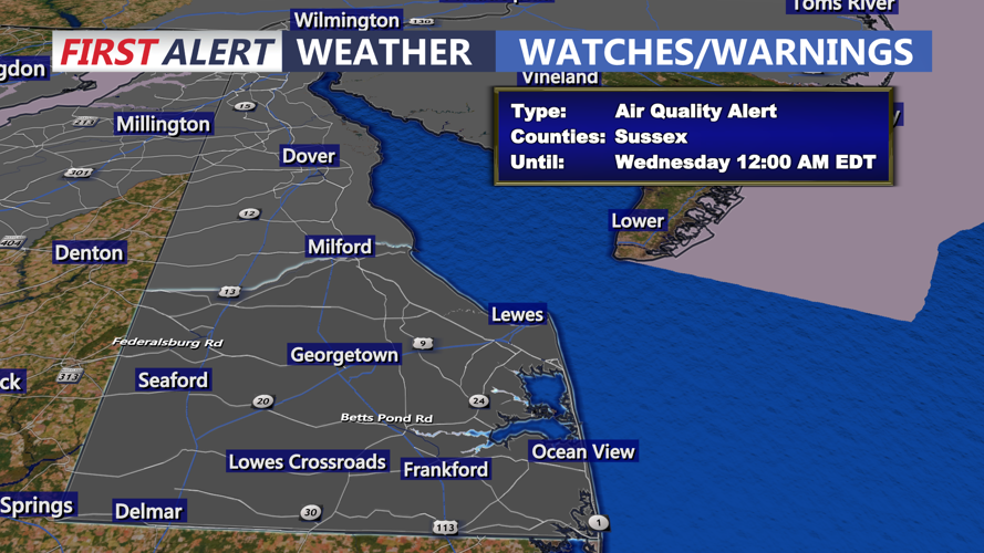
A Code Orange Air Quality Alert remains in effect for all of Delaware today through Wednesday. A Code Orange alert means air pollution levels may become unhealthy for sensitive groups, including children, older adults, people with asthma, heart disease or other lung diseases. Those in sensitive groups should limit strenuous outdoor activity and prolonged outdoor exercise.

Code ORANGE air quality alert for all of Delaware, unhealthy for sensitive groups, avoid long periods outdoors.
Beachgoers should also use caution, as there is a MODERATE risk for the development of dangerous and life-threatening rip currents along the Delaware beaches.
Tonight will stay very warm under mostly clear skies, with temperatures only falling into the upper 60s to lower 70s. Some record warm low temperatures may be challenged as well, with the record warm low in Georgetown standing at 73 degrees from 2017.

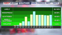
Cold front will bring storm chance Wednesday evening, unsettled conditions develop through Memorial Day Weekend.
Wednesday will bring one more day of scorching heat across Delmarva, with highs again reaching the mid 90s inland. Georgetown may come close to its daily record high of 95 degrees, set in 1962.
A cold front will approach Delmarva later Wednesday and bring showers and thunderstorms into Wednesday night and Thursday. The timing of the front could allow storms to move into a hot and unstable air mass, creating the potential for isolated strong to severe thunderstorms. The Storm Prediction Center has placed the region under a Marginal Risk for severe weather on Wednesday. The main concerns with any stronger storms will be damaging wind gusts and large hail.
Most areas are expected to receive around a quarter inch of rain or less from the front, but heavier downpours could produce locally higher totals.
By Thursday, the front is expected to settle near or just south of Delmarva, keeping shower chances in the forecast, especially for southeastern areas. Temperatures will turn much cooler by the end of the week into the 50s and 60s.
An unsettled pattern may continue into Memorial Day weekend. A warm front is expected to lift through the region Saturday, but there is still uncertainty over how far north it will move and whether Delmarva can dry out by Sunday or Monday. For now, shower chances remain in the forecast through Memorial Day, with temperatures generally in the mid to upper 70s.
