


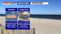
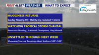
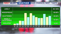
Seasonably warm and increasingly humid conditions will build across Delmarva Sunday afternoon as high pressure shifts offshore. Highs will reach into the 80s to near 90, with an isolated thunderstorm possible by evening. By Monday and into midweek, a tropical air mass will set the stage for daily rounds of showers and thunderstorms. Some storms could produce heavy rainfall, localized flooding, and dangerous heat indices approaching 100 degrees inland.
From
To

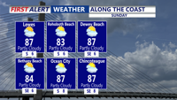
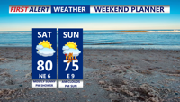
High pressure offshore will usher in warmer and more humid air over Delmarva on Sunday, with highs climbing into the 80s to near 90 and muggy nights returning. While most areas should remain dry through Sunday, an isolated thunderstorm cannot be ruled out. By Monday and into the rest of the week, tropical moisture and unstable conditions will bring daily chances for showers and thunderstorms, some capable of heavy rainfall and localized flooding.

Pleasant weather will continue Saturday night across Delmarva, with partly cloudy skies and lows in the 60s. As high pressure shifts offshore, temperatures and humidity will climb Sunday into Monday. By early next week, a tropical and unsettled pattern will bring daily chances of showers and thunderstorms, heavy rainfall, and heat indices over 100 degrees.

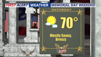
High pressure will maintain calm and seasonable weather across Delmarva through the holiday weekend. Temperatures will climb into the upper 80s and low 90s by Sunday, with humidity gradually increasing. By early next week, a tropical, unsettled pattern is expected to develop, bringing daily chances for showers and thunderstorms along with oppressive heat and potential localized flooding.

Rounds of showers and scattered thunderstorms as a stationary front lingers across the region. Locally heavy rain is possible, though widespread flooding is not expected. The dreary pattern will persist through Monday with cool, cloudy, and damp conditions. A gradual warmup begins midweek as Bermuda high pressure builds, eventually pushing temperatures back into the 80s and 90s by Thursday, with continued chances for afternoon storms.

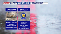
Delmarva will see rounds of showers and storms due to a stationary front stalled across the region. While locally heavy rain is possible, the risk of severe weather remains low. Temperatures will be below normal through early next week, with cloudy and drizzly conditions lingering. A midweek shift in the weather pattern will bring rising temperatures and a return to summer-like warmth by Wednesday, ahead of a cold front later in the week.

Sussex County can expect scattered showers Friday evening and again Saturday afternoon, with breezy conditions and temperatures remaining slightly below normal.

Delmarva will enjoy another mostly sunny day on Saturday as high pressure remains in control. A brief chance of showers is possible Saturday night, but conditions will return to dry by Sunday morning. Temperatures will stay seasonable through the weekend. As we look into the upcoming week, rain chances will increase by midweek, offering some relief to the ongoing dry conditions across the region.

Delmarva can expect pleasant weather over the weekend, with mostly sunny skies and seasonable temperatures. A meandering low-pressure system off the Jersey Shore will influence coastal cloudiness today, but otherwise, high pressure will dominate, bringing calm conditions. As we move into next week, there's a chance for some much-needed rain, with the highest likelihood around midweek.

A cold front moving through Delmarva early Thursday morning will bring a significant cool down after today's heat, with scattered storms possible this evening. Cooler temperatures and lingering clouds are expected through Friday morning.