


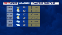
From early Thursday through early Friday, Sussex County’s beach communities will see persistent cloud cover, seasonable temperatures, and a low chance of spotty sprinkles before milder, wetter weather approaches overnight.
From
To

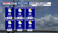
High pressure continues to move offshore this evening, as southerly winds pull in warmer air, allowing afternoon highs to reach the mid to upper 60s this weekend. We'll see a better chance of showers Sunday. Then a taste of winter early next week.

The unusually cool fall-like weather continues for Delmarva, with dry and mild days and cool nights continuing into the Labor Day holiday weekend.


A strong upper level low to our north will rotate rain, wind, and cold conditions into the region this afternoon and evening. The weekend will be dry and cool, but still breezy.

Delmarva will enjoy mostly sunny skies and above-average temperatures on Wednesday, with fair weather extending into Thursday.

An onshore flow and approaching warm front will bring more clouds and slightly warmer temperatures to the Delmarva region through Thursday. A brief chance of sprinkles or light showers exists Tuesday night, with high temperatures peaking in the 70s by Thursday.

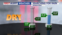
The dry weather continues for the foreseeable future for Delmarva. A series of cold fronts will cool us down from time to time the next several days. The fire danger remains elevated into next week.

A cold front will move through Delmarva late Wednesday night into early Thursday, bringing cooler temperatures, gusty winds, and dry conditions. Expect temperatures to drop to near-average levels by Thursday afternoon with fire weather concerns due to the dry air and strong winds.

A lingering upper-level low near New England will maintain cooler temperatures and scattered showers across Delmarva through Thursday, with conditions expected to gradually improve.