


DELMARVA - A closed upper-level low will continue to influence the weather across Delmarva as it shifts east-northeastward across New England tonight, possibly lingering around Maine into Thursday. This system will maintain cyclonic flow across the region, resulting in cooler conditions and some scattered showers through Thursday, particularly in the northern parts of the area.
Throughout the day, the combination of cold air aloft and boundary layer heating has produced a significant amount of cumulus cloud cover across the region. These clouds have shown more vertical growth in the northern areas of Delmarva, closer to the cold core of the upper-level low and the presence of the strongest shortwave. While the showers that develop are expected to be light, there is a slight chance for sprinkles, especially in the northern zones. Radar trends suggest an increased chance of scattered showers in these areas, though any precipitation further south is expected to be minimal and not widespread enough to mention in the forecast at this time.
As evening approaches and daytime heating diminishes, the cumulus clouds will likely flatten and dissipate, leading to clearer skies overnight. The northwesterly breeze that has been present during the afternoon will also calm down as the boundary layer stabilizes. With low dew points in place, temperatures will drop significantly overnight, with rural areas dipping to around 50 degrees and some spots seeing lows in the mid to upper 40s.
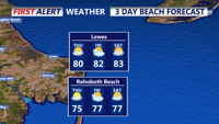
By Thursday, while the closed low will still exert some influence over Delmarva, the cyclonic flow will begin to weaken. This will lead to slightly higher heights aloft, translating to warmer conditions and less cloud development during the late morning and afternoon. A lighter northwest to west wind will develop, and after a cool start, temperatures are expected to rise into the mid to upper 70s across much of the region.
Overall, expect a continuation of cooler, unsettled weather through Thursday, with gradual improvement as the upper-level low moves farther away.