


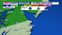
Monday marks the beginning of another stretch of unsettled weather for Delmarva, as a stalled front remains north of the region, setting the stage for a series of thunderstorms into Tuesday, along with very warm and muggy conditions.
From
To

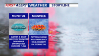
Delmarva begins the week with damp, gray skies and cooler temperatures, but change is on the horizon. After periods of drizzle and light showers Monday and Tuesday, warmer and more humid air arrives midweek. By Thursday, temperatures could soar into the 90s with strong to severe storms possible as a cold front sweeps through. The weekend looks drier and more comfortable with sunshine and highs in the 80s.

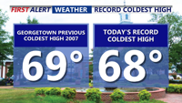
Father’s Day on Delmarva was one for the weather record books—Georgetown set a new daily cold high mark of 68°F, the third chilliest Father’s Day on record. Overcast and cool conditions linger through Monday with scattered drizzle and showers possible. A slow transition to a warmer and stormier pattern begins Tuesday, peaking Thursday with near-record heat and a risk of severe storms. Cooler, more settled weather returns for Friday and the weekend.


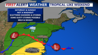
Saturday night brings patchy fog and muggy conditions to Delmarva before an unsettled weather pattern Sunday introduces the risk of strong to severe storms. Following a few days of active weather, high pressure returns midweek with sunny skies and temperatures reaching into the upper 80s to near 90 degrees.

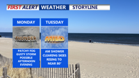
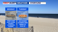
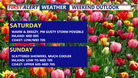
A damp and stormy weekend as unsettled weather takes hold. A weak cold front and associated low pressure system will bring widespread showers and possible thunderstorms Saturday, followed by another round Sunday afternoon with the arrival of a warm front. The Storm Prediction Center places Delmarva under a Marginal Risk for severe weather Saturday, with damaging winds as the main concern. Intermittent clearing arrives Monday before a fresh round of storms hits Tuesday.


A powerful storm system is set to bring heavy rain, potential flooding, and strong thunderstorms to Sussex County from late Friday through Saturday evening.

A strong cold front will sweep through Delmarva late Saturday, bringing potential severe thunderstorms with damaging winds and hail. Following the front, Sunday through Tuesday will feature dry and breezy conditions with lower humidity and cooler temperatures. Unsettled weather may return midweek with a chance for rain by Wednesday.

A slow-moving weather system will bring showers and a slight risk of severe storms to Delmarva early in the week, with milder and partly sunny conditions expected by midweek. A cold front arrives late Wednesday into Thursday, ushering in cooler air and the chance of spotty showers. Temperatures will rebound slightly over the weekend as high pressure returns.

A slow-moving upper-level system will bring rounds of showers and potential storms to Delmarva through midweek, followed by improving weather and cooler temperatures heading into the weekend. Monday and Tuesday will remain mild with highs in the 70s, but a late week cold front could trigger thunderstorms with damaging winds and hail before high pressure settles in by the weekend.

Warm, breezy conditions Saturday will give way to increasing shower and storm chances late this weekend across Delmarva. While severe weather remains unlikely, heavy rain and thunderstorms could impact the area Sunday and early next week as a slow-moving front lingers.