


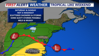


DELMARVA -- Saturday afternoon will mark the beginning of an unsettled stretch of weather across the Delmarva Peninsula, as a weak low-pressure system riding a cold front sweeps through the region. The system, expected to pass through by late Saturday, will bring widespread showers and scattered thunderstorms throughout the day.

Mild and muggy with a few showers and gusty storms possible into Saturday evening.
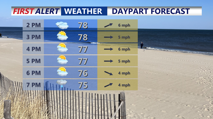
Cloud cover and persistent rain will keep temperatures a few degrees cooler than Friday, with highs topping out in the upper 70s to low 80s. While the air will feel slightly less oppressive than earlier in the week, humidity will remain notable, with dew points hovering in the upper 60s.
Atmospheric conditions suggest a modest potential for strong storms. As a result, the Storm Prediction Center has placed Delmarva under a Marginal Risk (Level 1 of 5) for severe weather on Saturday. Damaging wind gusts are the primary threat with any stronger storms that may develop.
By Saturday evening, showers and storms are expected to taper off as high pressure begins to build in from the north. However, the reprieve will be short-lived. Temperatures overnight will dip into the lower 60s, and while slightly drier air will filter in, conditions will remain humid.

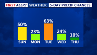
Keep the unsettled conditions in play through at least Tuesday.
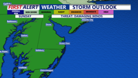
On Sunday, the base of that high pressure system will lift northward, making way for the next round of unsettled weather. A developing area of low pressure to the west will extend a warm front that lifts through the area, bringing another opportunity for scattered showers and thunderstorms by Sunday afternoon. Temperatures are forecast to reach the mid to upper 70s. The Storm Prediction Center has a Marginal Risk (1 of 5) of severe weather for Sunday as well, with damaging winds being the primary threat.

Storm Prediction Center has the entire area under a "Marginal" (1 of 5) risk Sunday PM for the threat of an isolated severe storm. Damaging winds is the primary threat.
Looking ahead to the start of the workweek, the weather remains active. Another low-pressure system will cross the region Sunday night into Monday morning, with more thunderstorms likely. Conditions may briefly dry out Monday afternoon and evening before a cold front arrives Tuesday, potentially triggering another round of storms into early Wednesday.
Relief is on the horizon: By midweek, high pressure will finally settle in, bringing dry conditions and highs climbing into the 80s by Thursday.
