





Delmarva will enjoy a pleasant Friday with partly cloudy skies, lighter northeast winds and cooler temperatures compared to Thursday. Temperatures will range from the low to mid 60s at the beaches to the 70s inland, with some lower shore communities nearing 80 degrees. A spotty shower is possible Friday evening into the overnight, but the bigger change arrives this weekend as low pressure brings widespread rain, chilly temperatures and breezy coastal conditions. Rainfall totals from Friday night through Sunday may reach half an inch to slightly over an inch inches across the area, providing beneficial rainfall despite the soggy weekend.
From
To


Today stays warm and sunny across Delmarva, but temperatures step down from yesterday’s record highs. Cooler air arrives near the coast Saturday as a backdoor front pushes in, while inland areas stay milder. Minor tidal flooding is expected along the Delaware coast and Delaware Bay Saturday evening into Saturday night, followed by showers, a few thunderstorms, and a sharp cool down late Saturday night into Sunday. Much colder air settles in early next week, with widespread frost or freeze conditions likely Monday night into Tuesday morning.

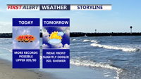
Today marks the third straight day of record-setting heat potential across Delmarva, with highs reaching the upper 80s to around 90 under partly cloudy skies. Dry air, gusty southwest winds, and ongoing drought conditions will also create an elevated fire weather risk. A weak front brings only slight cooling Friday, while a sharper cooldown arrives over the weekend with much-needed rain late Saturday night into Sunday. Early next week turns significantly cooler, with frost or even freeze conditions possible by Monday night into Tuesday morning before temperatures rebound by midweek.

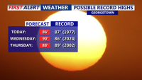
Today brings unseasonably warm weather to Delmarva with highs in the mid 80s under mostly sunny skies, though areas near the bay and ocean will stay a bit cooler in the upper 70s to low 80s. Georgetown and Salisbury could come close to their daily record highs of 87 degrees. The warmth continues tonight and intensifies Wednesday, when record highs are likely as temperatures approach 90. Conditions stay well above normal through the weekend before shower and thunderstorm chances return Sunday ahead of a strong cold front. Much cooler air arrives next week with highs falling back into the 50s and 60s.


Today stays below average across Delmarva with partly sunny skies, highs in the upper 30s to low 40s, and a cold east-northeast wind off the ocean keeping conditions raw. Tonight turns partly cloudy with lows in the upper 20s to low 30s. The chill lingers Thursday before a warmer trend arrives Friday, the first day of spring, with highs near 60. Even warmer air builds in for the weekend, pushing temperatures into the 60s Saturday and low 70s inland Sunday before showers and cooler air return early next week.

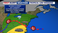
A damp and stormy weekend as unsettled weather takes hold. A weak cold front and associated low pressure system will bring widespread showers and possible thunderstorms Saturday, followed by another round Sunday afternoon with the arrival of a warm front. The Storm Prediction Center places Delmarva under a Marginal Risk for severe weather Saturday, with damaging winds as the main concern. Intermittent clearing arrives Monday before a fresh round of storms hits Tuesday.

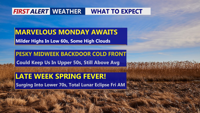
Delmarva will see a stretch of dry and mild weather beginning Monday, with sunshine and highs in the low to mid-60s inland and 50s along the coast. Southwest winds will push temperatures even higher Tuesday before a midweek cooldown. A backdoor cold front will briefly lower temperatures Wednesday before shifting north again, allowing a warming trend into the weekend. Highs could reach the low 70s by Saturday, with rain chances returning Sunday night.

DELMARVA - On Saturday, a disorganized shortwave will move from the upper Ohio Valley across the Middle Atlantic region, accompanied by a weak…