Mother’s Day should begin mild and partly sunny in Sussex County before clouds increase and rain chances rise Sunday night into early Monday.
Mother’s Day should begin mild and partly sunny in Sussex County before clouds increase and rain chances rise Sunday night into early Monday.
Delmarva saw light rainfall overnight into this morning, but totals were not enough to make a major dent in dry conditions. Skies will gradually clear later today with temperatures in the 50s and 60s. Friday looks bright and breezy, followed by a warmer Mother’s Day weekend with shower and thunderstorm chances returning Saturday and again Sunday night into Monday.
A cold but mostly quiet Sunday afternoon will lead into a chilly night, followed by slightly milder temperatures Monday as high pressure moves offshore.
Saturday brought tropical downpours and flash flooding to parts of Delmarva, especially in Worcester County. While not everyone saw rain, Ocean City and Berlin were inundated with 3 to 4 inches of rainfall in just a few hours. A muggy night with lingering showers will be followed by heat and the threat of isolated severe storms Sunday. A cold front is expected to bring relief into early next week before humidity builds again by the end of the week.
The Delmarva region will see another stretch of dry, sunny weather from early Saturday into early Sunday, before warmer and more humid conditions gradually build in.
Sunday brings a refreshing start to June on Delmarva, with dry conditions, cool temperatures, and a light breeze. High pressure will dominate the region through midweek, setting the stage for a warming trend that could bring the first 90-degree day of the year by Thursday.
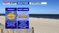
Storms have come to an end, clear and chilly night on tap as some areas away from the coast fall into the 40s. Bright, beautiful, breezy end to the weekend, summer-like next week as we make a run at our first 90 degree day of the year.
Temperatures gradual tumble Sunday afternoon after above-average warmth across Delmarva, a cold front ushers in steady rain overnight into Monday. A drastic drop in temperatures begins Monday, with widespread 40s and gusty winds expected by Tuesday. Conditions will remain dry but chilly midweek, before a potential return of rain on Friday.
We can continue to look forward to a dry, pleasant weekend beginning Saturday night with mild temperatures and partly cloudy skies. Sunday promises seasonable, mostly sunny conditions, while a gradual warming trend kicks in early next week with highs climbing into the 50s and 60s. Later in the week, a stronger cold front brings our best chance for rain on Thursday before a cooler Canadian air mass returns Friday.
Freezing rain on Saturday morning will transition to rain, with warmer and drier conditions expected across Delmarva by Sunday.