


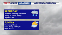
Today starts a much calmer pattern across Delmarva after several days of wild weather that included temperature swings, record highs, and accumulating snow. Skies will be mostly sunny with highs in the upper 40s to low 50s, though gusty south winds will ramp up this afternoon and evening to 35 to 40 mph. The weekend looks pleasant, with sunshine Saturday, more clouds Sunday, and temperatures warming into the upper 50s, 60s, and eventually near 70 by Monday ahead of a powerful cold front. That front could bring strong to severe thunderstorms Monday afternoon and evening, along with heavy rain and damaging wind gusts, before much colder air rushes back in for Tuesday and Wednesday.
From
To

Sussex County is expected to warm into the 50s on Wednesday before late-night rain potentially mixes with snow and temperatures drop sharply toward early Thursday, raising the risk of icy spots.


Sussex County is expected to stay relatively mild through Wednesday, but rain developing late Wednesday night could mix with snow as temperatures fall, increasing the risk of icy spots early Thursday.

Delmarva stays unseasonably mild Friday, then turns wetter Saturday with heavy rain at times before blustery, colder air pushes in Sunday.


Mild temperatures and scattered showers move through Delmarva today ahead of a strong cold front, followed by gusty winds and a return to winterlike cold through the week.


Rain clears early Monday as a strong cold front brings gusty winds and falling temperatures into early Tuesday.


Mild, quiet conditions today will be short-lived as rain, gusty winds and a sharp temperature drop arrive overnight into Friday.

Light rain ends early Sunday evening before colder, gusty conditions settle in.


A strong cold front will sweep through late Wednesday, bringing gusty winds and a sharp drop in temperatures into Thursday.

Mild, damp conditions early Wednesday will quickly give way to a windy, colder stretch from Wednesday evening into early Thursday across Sussex County.