...SMALL CRAFT ADVISORY NOW IN EFFECT UNTIL 3 AM EDT MONDAY...
* WHAT...Southwest winds 10 to 15 kt with gusts up to 25 kt and
a moderate chop.
* WHERE...Delaware Bay waters north of East Point NJ to
Slaughter Beach DE and Delaware Bay waters south of East Point
NJ to Slaughter Beach DE.
* WHEN...Until 3 AM EDT Monday.
* IMPACTS...Conditions will be hazardous to small craft.
PRECAUTIONARY/PREPAREDNESS ACTIONS...
Inexperienced mariners, especially those operating smaller
vessels, should avoid navigating in hazardous conditions.
&&
Weather Alert
SEVERE THUNDERSTORM WATCH 337 REMAINS VALID UNTIL 1 AM EDT MONDAY
FOR THE FOLLOWING AREAS
THIS WATCH INCLUDES THE FOLLOWING ADJACENT COASTAL WATERS
DELAWARE BAY WATERS NORTH OF EAST POINT NJ TO SLAUGHTER BEACH DE
DELAWARE BAY WATERS SOUTH OF EAST POINT NJ TO SLAUGHTER BEACH DE
COASTAL WATERS FROM LITTLE EGG INLET TO GREAT EGG INLET NJ OUT
20 NM
COASTAL WATERS FROM GREAT EGG INLET TO CAPE MAY NJ OUT 20 NM
COASTAL WATERS FROM CAPE MAY NJ TO CAPE HENLOPEN DE OUT 20 NM
COASTAL WATERS FROM CAPE HENLOPEN TO FENWICK ISLAND DE OUT 20 NM
Weather Alert
SEVERE THUNDERSTORM WATCH 337 REMAINS VALID UNTIL 1 AM EDT MONDAY
FOR THE FOLLOWING AREAS
IN DELAWARE THIS WATCH INCLUDES 3 COUNTIES
IN CENTRAL DELAWARE
KENT
IN NORTHERN DELAWARE
NEW CASTLE
IN SOUTHERN DELAWARE
SUSSEX
IN MARYLAND THIS WATCH INCLUDES 4 COUNTIES
IN NORTHEAST MARYLAND
CAROLINE KENT QUEEN ANNE'S
TALBOT
IN NEW JERSEY THIS WATCH INCLUDES 13 COUNTIES
IN CENTRAL NEW JERSEY
MERCER
IN NORTHERN NEW JERSEY
HUNTERDON MORRIS SOMERSET
SUSSEX WARREN
IN SOUTHERN NEW JERSEY
ATLANTIC BURLINGTON CAMDEN
CAPE MAY CUMBERLAND GLOUCESTER
SALEM
IN PENNSYLVANIA THIS WATCH INCLUDES 5 COUNTIES
IN SOUTHEAST PENNSYLVANIA
BUCKS CHESTER DELAWARE
MONTGOMERY PHILADELPHIA
THIS INCLUDES THE CITIES OF ATLANTIC CITY, BLAIRSTOWN, CAMDEN,
CENTREVILLE, CHERRY HILL, CHESTERTOWN, DENTON, DEPTFORD, DOVER,
DOYLESTOWN, EASTON, FLEMINGTON, GEORGETOWN, GLASSBORO, HAMMONTON,
MEDIA, MILLVILLE, MOORESTOWN, MORRISTOWN, MOUNT HOLLY, NEWTON,
NORRISTOWN, OCEAN CITY, PENNSVILLE, PHILADELPHIA, SOMERSET,
TRENTON, WEST CHESTER, AND WILMINGTON.
Weather Alert
...COASTAL FLOOD ADVISORY REMAINS IN EFFECT UNTIL 1 AM EDT
MONDAY...
* WHAT...Up to one foot of inundation above ground level
expected in low-lying areas near shorelines and tidal
waterways.
* WHERE...Kent, Inland Sussex and Delaware Beaches.
* WHEN...Until 1 AM EDT Monday.
* IMPACTS...At this level, flooding begins on the most
vulnerable roads in coastal and bayside communities, and along
inland tidal waterways. Some partial or full road closures are
possible.
PRECAUTIONARY/PREPAREDNESS ACTIONS...
A Coastal Flood Advisory means that minor tidal flooding is
expected. Minor tidal flooding often results in some road
closures. Usually, the most vulnerable roadways will flood.
Do not leave your vehicle at a location that is prone to tidal
flooding. Do not drive your vehicle through flood waters. The
water may be deeper than you think it is. You will be putting
yourself in danger and your vehicle may be damaged, leading to
costly repairs.
Visit the National Water Prediction Service at
https://water.noaa.gov/wfo/phi for additional water level and
flood impact information for your local tide gauge.
&&
Time of high total tides are approximate to the nearest hour.
Murderkill River at Bowers Beach
MLLW Categories - Minor 6.6 ft, Moderate 7.6 ft, Major 8.6 ft
MHHW Categories - Minor 0.9 ft, Moderate 1.9 ft, Major 2.9 ft
Total Total Departure
Day/Time Tide Tide from Norm Flood
ft MLLW ft MHHW ft Impact
-------- --------- --------- --------- --------
14/10 PM 7.1 1.4 0.1 Minor
15/10 AM 4.9 -0.8 0.1 None
15/10 PM 7.1 1.4 0.1 Minor
16/11 AM 5.0 -0.7 0.1 None
16/11 PM 7.3 1.6 0.4 Minor
17/12 PM 5.5 -0.2 0.6 None
Delaware Bay at Lewes
MLLW Categories - Minor 6.0 ft, Moderate 7.0 ft, Major 8.0 ft
MHHW Categories - Minor 1.3 ft, Moderate 2.3 ft, Major 3.3 ft
Total Total Departure
Day/Time Tide Tide from Norm Flood
ft MLLW ft MHHW ft Impact
-------- --------- --------- --------- --------
14/09 PM 6.6 2.0 1.0 Minor
15/09 AM 4.6 -0.0 0.8 None
15/10 PM 6.4 1.8 0.8 Minor
16/10 AM 4.8 0.2 0.9 None
16/11 PM 6.5 1.8 1.0 Minor
17/11 AM 4.8 0.2 0.9 None
&&
Mostly sunny windy Friday, highs 46 to 55 on Delmarva.
Chris Mastrobuono is a South Philly native, but has come to join
the CoastTV meteorology team. With over three years of experience
delivering accurate, passionate and insightful weather analysis, he
is eager to report on the coast. Previously, he spent over two
years as a morning meteorologist at WEVV CBS/FOX in Evansville,
Indiana.
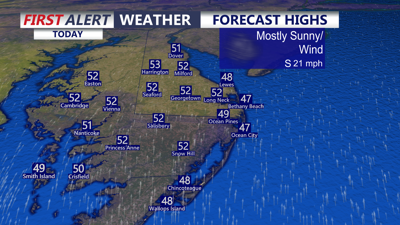
DELMARVA -- Today brings a much calmer weather pattern to Delmarva after a wild stretch that featured dramatic temperature swings, record warmth, and even accumulating snow in some spots. Mostly sunny skies will help temperatures climb into the upper 40s to low 50s this afternoon, which is a little below average for this time of year.
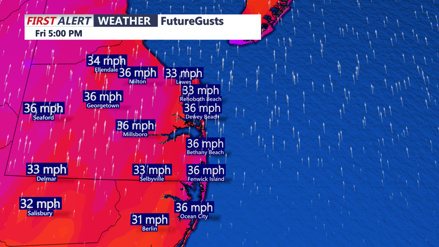
Even though the sun will be out, winds will quickly become the main weather story. As low pressure tracks north of the region, a tightening pressure gradient will send south winds gusting to 35 to 40 mph this afternoon and into the evening.
Winds will gust out of the south to near 40 mph this afternoon into the evening.
Those breezy conditions will keep temperatures from falling too quickly overnight, with lows staying in the low to mid 40s by Saturday morning.
Staying dry through the weekend, next storm system brings showers early Monday and potential strong to severe storms Monday afternoon-evening.
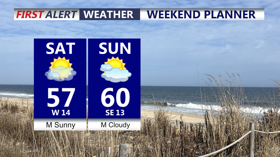
The weekend looks very nice across the peninsula. On Saturday, departing low pressure over northern New England and building high pressure from the Great Lakes will create a strong west to northwest breeze across the Mid-Atlantic. Even so, sunshine will dominate, with highs reaching the mid to upper 50s inland and staying in the 50s at the beaches. Sunday will turn a bit cloudier, but conditions remain pleasant with highs in the low 60s.
Pleasant weekend on tap, breezy Saturday, increasing clouds slightly milder Sunday.
By Monday, the weather turns much more active. Warmer, more humid air will surge into Delmarva ahead of a strong cold front sweeping east from a deepening storm system moving through the Great Lakes into Canada. Showers may begin developing Sunday night into Monday morning as warm air advection increases and deeper moisture arrives. A rumble of thunder cannot be ruled out late Sunday night.
Despite the showers, temperatures on Monday will rise well into the 60s across much of the region, with some lower 70s possible. Humidity will also increase noticeably, with dew points pushing toward 60 degrees. Through the day, widespread showers and thunderstorms are expected to develop as the approaching front and strong upper-level system provide increasing lift.
There is growing concern that some of those thunderstorms could become strong to severe Monday afternoon and evening. While cloud cover and ongoing showers may limit instability somewhat, the atmosphere will feature very strong wind fields and impressive wind shear. That setup could support a squall line or fast-moving line segments capable of producing locally damaging wind gusts. If surface winds remain favorably aligned, some storm rotation may also develop. Heavy rain is also likely at times, with plenty of moisture in place ahead of the front.
Once the cold front pushes offshore Monday night, much colder air will spill back into Delmarva. Gusty winds will shift from the south to the west and northwest, with gusts again reaching 30 to 40 mph. There is a small chance lingering precipitation could briefly mix with or change to snow before ending, though that will depend on how quickly the moisture exits behind the front.
Tuesday, St. Patrick's Day will feel sharply colder, with some areas struggling to reach 40 degrees for afternoon highs. A gusty westerly wind will make it feel even colder, with wind chills dropping into the 20s and 30s. Wednesday stays chilly as well, although winds should ease some compared to Tuesday.
Chris Mastrobuono is a South Philly native, but has come to join
the CoastTV meteorology team. With over three years of experience
delivering accurate, passionate and insightful weather analysis, he
is eager to report on the coast. Previously, he spent over two
years as a morning meteorologist at WEVV CBS/FOX in Evansville,
Indiana.