


Delmarva will enjoy a stretch of mild and dry weather through the upcoming week, with temperatures gradually warming into the mid-60s to low-70s by the weekend. A backdoor cold front will briefly cool things down midweek before shifting northward, allowing temperatures to rebound. The next significant chance of rain arrives Sunday night with an approaching cold front.
From
To

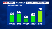
Delmarva will experience clear and chilly conditions Sunday night, with lows in the mid-30s. A warming trend kicks off Monday, with highs reaching the low to mid-60s under mostly sunny skies. A stronger low will move in Monday night into Tuesday, lifting a warm front northward. By Tuesday, temperatures will climb further into the 60s, though a backdoor cold front could bring midweek uncertainty. A high-pressure system will briefly cool things down Wednesday before warmer air returns later in the week. By Saturday, highs could push into the upper 60s to low 70s.


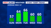
Delmarva will see sunny but breezy conditions Sunday, with highs in the mid to upper 50s and gusts up to 30 mph, raising fire concerns. A warming trend begins Monday, with highs reaching the low to mid-60s under mostly sunny skies. Temperatures climb further Tuesday, but a backdoor cold front could limit Wednesday’s warmth. By Thursday, temperatures rebound into the 50s and 60s, with a continued warm stretch into the weekend. Highs could reach the upper 60s to low 70s by Saturday.


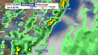
After a drastic 40- to 45-degree temperature drop, Sunday night will remain clear and cold across Delmarva, with lows in the low to mid-20s. High pressure will maintain dry conditions through Tuesday before a strong storm system moves in midweek. By Wednesday, widespread rain, strong winds, and possibly severe weather are expected as a powerful cold front pushes through. Cooler, calmer weather returns Friday, but another system may bring rain or snow by the weekend.

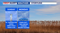
Delmarva is experiencing a dramatic temperature drop as arctic air grips the region, with highs in the 30s Sunday but wind chills making it feel like the teens and 20s. High pressure will keep conditions dry and mostly sunny through Tuesday before a strong storm system moves in midweek, bringing the potential for heavy rain, strong winds, and possibly severe weather Wednesday into Wednesday night.

Delmarva will experience cooler and unsettled weather on Saturday, with a frontal system bringing showers and a chance of thunderstorms. Highs will be in the 70s on Saturday, cooling to the upper 60s on Sunday before rebounding into the 80s next week. Expect partly to mostly sunny skies and comfortable humidity levels through the week.

A high-pressure system currently over the Delmarva Peninsula will keep temperatures below normal through tonight, with clear and cool conditions expected. As this high pressure moves offshore into the weekend, temperatures will rebound to near-normal levels. By early next week, an approaching weather system will bring increased chances for showers and thunderstorms.