


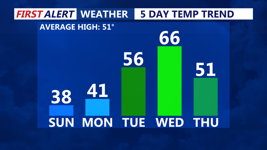


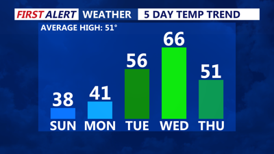
DELMARVA -- After a dramatic temperature swing from Saturday’s warmth, Delmarva remains locked in an arctic chill Sunday night. Despite sunshine throughout the day, temperatures struggled to climb, and wind chills made it feel like the teens and 20s. The region will stay clear but frigid overnight, with lows dropping into the low to mid-20s.
A strong area of high pressure will settle in Sunday night, keeping conditions dry but cold into Monday. Skies will remain mostly sunny to start the workweek, with temperatures climbing slightly into the upper 30s to low 40s. Monday night will be another cold one, with lows dipping into the teens and 20s once again.
By Tuesday, winds will begin shifting to a more southerly direction, allowing for a noticeable warm-up. Highs will surge into the 50s for most of the region, although coastal areas may stay in the 40s. Clouds will gradually increase ahead of an approaching storm system, which is expected to bring significant weather impacts midweek.
A potent storm system moving in from the central U.S. will reach Delmarva by Wednesday, bringing widespread rain and gusty winds. Showers may begin late Tuesday night, but the heaviest rain is expected Wednesday afternoon and evening as a strong cold front moves through.

Watching potential for severe storms Wednesday PM.
While atmospheric instability is uncertain, the combination of strong winds and forcing aloft could lead to severe weather. . If temperatures climb into the 60s ahead of the front, the risk for severe storms could increase further.
The system will clear out late Wednesday night, but gusty winds may linger into Thursday as cooler air settles back into the region.
Thursday and Friday will bring drier conditions with near-normal temperatures in the 40s to low 50s. However, another weak system may approach by Saturday, possibly bringing rain or even a wintry mix.