


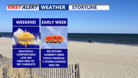
Delmarva will enjoy a stretch of sunny, comfortable weather from Saturday through Monday, with only light breezes and mild temperatures. However a HIGH risk of rip currents remains for all beach points in Delaware, to Ocean City to Chincoteague. Conditions will heat up by midweek, with highs in the 90s, rising humidity, and a chance for scattered afternoon storms.
From
To


Delmarva will enjoy clear skies and comfortable temperatures Friday night through the weekend as high pressure lingers over the region. Temperatures will gradually warm into early next week, with highs nearing the 90s by midweek as humidity increases and scattered storms become possible.

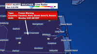
A Freeze Warning is in effect for parts of Delmarva from 2 a.m. to 9 a.m. Monday, as temperatures dip below freezing overnight. Expect a sunny and cool day Monday, with gradual warming and mild conditions by Tuesday.

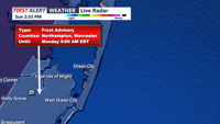
The National Weather Service in Mount Holly has issued Freeze Warnings and Frost Advisories for much of the Delmarva region overnight as temperatures are expected to dip below freezing in many areas.


A coastal low off the Mid-Atlantic will bring a few scattered showers to Delmarva through Friday. As high pressure builds over the weekend, weather conditions will improve, leading to drier and more tranquil weather by Saturday afternoon. Temperatures will remain mild, with highs in the mid-70s to low 80s on Thursday, and cooler conditions expected over the weekend. A cold front may bring more showers by the middle of next week.

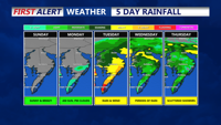
Surface high pressure will dominate Delmarva's weather through early next week, bringing mostly clear skies and seasonable temperatures. Expect calm conditions tonight with lows in the low to mid 60s, and areas of patchy fog, which could be dense in some spots. Sunday will feature sunny skies with temperatures near 80 degrees and breezy conditions, especially along the coast. High pressure will gradually move offshore, but tranquil weather continues into Monday. A disturbance off the Southeastern U.S. coast may bring rain chances back to the region by Tuesday and Wednesday, with increasing clouds and humidity. Highs will remain in the upper 70s, with precipitation chances peaking midweek before high pressure potentially returns late next week.

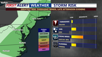
Delmarva will experience the passage of a cold front, bringing the potential for showers and isolated severe storms. Damaging winds are the primary threat, but the storms will be shorter and weaker than those seen on Sunday. Expect a significant drop in dew points and a shift to cooler, more comfortable air by tomorrow morning, with highs in the 70s and lows in the 50s. Dry, tranquil weather will continue through the rest of the week, with a secondary cold front on Tuesday night leading to even lower dew points and autumn-like temperatures.