


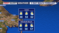
Light showers will affect Sussex County early Wednesday before drier weather arrives Wednesday night into early Thursday.
From
To

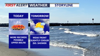
Today marks the third straight day of record-setting heat potential across Delmarva, with highs reaching the upper 80s to around 90 under partly cloudy skies. Dry air, gusty southwest winds, and ongoing drought conditions will also create an elevated fire weather risk. A weak front brings only slight cooling Friday, while a sharper cooldown arrives over the weekend with much-needed rain late Saturday night into Sunday. Early next week turns significantly cooler, with frost or even freeze conditions possible by Monday night into Tuesday morning before temperatures rebound by midweek.


Today brings unseasonably warm weather to Delmarva with highs in the mid 80s under mostly sunny skies, though areas near the bay and ocean will stay a bit cooler in the upper 70s to low 80s. Georgetown and Salisbury could come close to their daily record highs of 87 degrees. The warmth continues tonight and intensifies Wednesday, when record highs are likely as temperatures approach 90. Conditions stay well above normal through the weekend before shower and thunderstorm chances return Sunday ahead of a strong cold front. Much cooler air arrives next week with highs falling back into the 50s and 60s.


A warm front has lifted north of our region, ushering in a summer-like airmass for the week ahead.


DELMARVA - Tonight, as a southerly breeze develops, clouds increase a bit and temperatures will be a bit milder, with low to mid 50s. Temperat…


Near record warmth this afternoon, Easter Sunday becomes rainy with storms possible.


Clouds and fog are expected to linger in Sussex County from late Thursday night into much of Friday morning before warmer air pushes in and lifts temperatures well into the 70s by late Friday afternoon.


Lingering rain early Thursday should give way to cooler, variable conditions before a warm front brings a chance of light rain and patchy fog late Thursday night into early Friday.


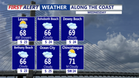
Delmarva starts the week on a warm and breezy note as a warm front lifts through the region, sending temperatures near 70 today and close to 80 Tuesday. Even warmer air builds in Wednesday, with record highs potentially challenged inland before a cold front brings the chance for afternoon and evening showers and thunderstorms. That front may stall nearby, keeping the weather unsettled through the weekend with periodic shower chances, but no day looks like a washout.

Sussex County is expected to stay mainly dry from early Thursday morning through Friday morning as temperatures begin to warm.