


Sussex County sees increasing clouds Tuesday with rain developing by midday and continuing into the night.
From
To


Sussex County stays mostly clear tonight before clouds thicken and rain arrives by late Tuesday afternoon.


A stagnant and damp start on Tuesday will give way to summerlike heat and a growing threat of severe thunderstorms by Wednesday and Thursday across Sussex County.


A stalled front will keep beach areas cool and damp into Tuesday while inland Sussex County sees a transition to warmer, more humid conditions with afternoon storm chances.

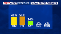
From foggy Thursday mornings to warmer, stormier starts by Saturday, Sussex County will see unsettled and humid conditions along the coast with periods of showers and potential thunderstorms.


A warm front will lift north through Sussex County Thursday night, followed by a humid Friday ahead of a slow-moving cold front that may bring scattered thunderstorms by Saturday.

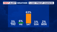
Sussex County will enjoy warm, fair weather from early Thursday through Friday before a cold front brings rain and possible thunderstorms late Friday into early Saturday.

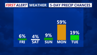
From Friday morning through early Sunday, Sussex County will enjoy mild mornings, highs in the 70s, and a few scattered showers as a warm front lifts north.

A stretch of unseasonably warm weather arrives late Thursday through Friday evening, bringing sunshine, showers, and highs climbing into the 70s by the weekend.