


DELMARVA - Sussex County residents can look forward to an extended stretch of mild spring weather through Friday, with conditions gradually becoming more humid ahead of a late-week storm system. A departing high pressure system off the East Coast will maintain fair skies and light winds Thursday into Friday, while drawing in warmer air from the south.
Temperatures on Thursday will range from the mid to upper 70s inland, with cooler readings near the beaches in the 60s to low 70s due to sea-breeze development. Skies will remain mostly sunny to partly cloudy, and no precipitation is expected during this period. Thursday night will be mild, with lows in the 50s and increasing clouds as moisture starts to build over the region.
By Friday, the warming trend continues with highs again reaching into the 70s, but with noticeably higher humidity. Low clouds may linger near the coast during the morning hours, especially in areas like Rehoboth Beach and Dewey Beach. Otherwise, skies will feature a mix of sun and clouds during the day.
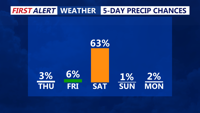
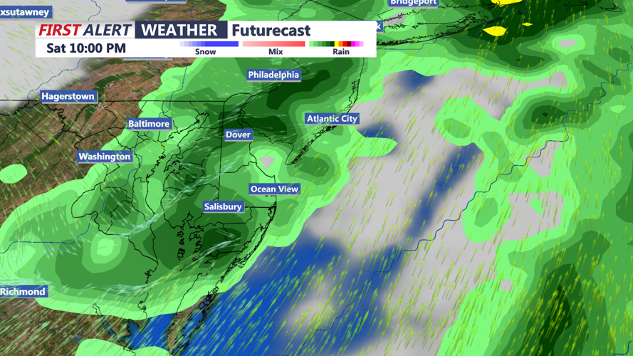
The next weather maker—a developing low-pressure system lifting out of the Ohio Valley—will approach late Friday into early Saturday. Its associated cold front is expected to sweep through Delaware early Saturday morning, bringing a period of moderate to heavy rain and possibly a few thunderstorms. While severe weather is not expected, locally heavy downpours could result in brief ponding on roadways.
Rainfall amounts could exceed one inch in some spots, especially where thunderstorms develop. Showers will taper off by midday Saturday, followed by a return to drier and cooler conditions as high pressure builds in behind the front.
