


A dry and unseasonably warm Thursday in Sussex County is expected to give way to cooler conditions by early Friday as a backdoor cold front moves into the region.
From
To


Light rain and patchy fog late tonight are expected to give way to a dry, warmer Thursday across Sussex County.


Sussex County, Delaware, is expected to stay very warm from early Wednesday morning through early Thursday morning, with only a slight and uncertain chance of an afternoon or evening thunderstorm Wednesday.


Unseasonably warm and dry weather is expected from early Tuesday through early Wednesday across Sussex County and the beach towns south to Ocean City.


A warm Monday night will give way to a dry, breezy and unusually warm Tuesday, with inland areas of Sussex County heating up much more than beach towns from Lewes to Ocean City.


Today brings a pleasant and mild start to the week across Delmarva with mostly cloudy skies, breezy southwest winds, and highs near 80 inland, while beach communities stay in the mid to upper 70s. A weak disturbance could spark an isolated light shower, mainly north and west of the peninsula. Warmer air then builds in through midweek and into the weekend, sending temperatures 15 to 30 degrees above average with some inland spots potentially reaching 90 degrees for the first time this year.

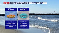
Today brings a burst of spring warmth to Delmarva with highs climbing into the mid to upper 70s inland and upper 60s at the beaches under partly cloudy skies and gusty southwest winds. A cold front moves through Friday, bringing late morning showers and scattered rain through the afternoon and evening as temperatures steadily fall. Chilly air settles in for Saturday, but a milder and more unsettled pattern returns by early next week with several rain chances and temperatures potentially nearing 80 by Wednesday and Thursday.


Patchy fog may brush parts of Sussex County late Tuesday night into early Wednesday, followed by unusually warm, more humid weather Wednesday and a growing chance of showers late in the day.


Sussex County is expected to see near-record warmth and increasing humidity Wednesday, followed by showers and a chance of strong thunderstorms late Wednesday night into Thursday morning.


Today brings sunshine and unseasonably warm weather across Delmarva, with inland temperatures rising into the upper 60s and low 70s, while areas along the Bay and beaches stay cooler in the 50s and 60s. More fog is expected tonight under mainly clear skies, with lows in the upper 40s inland and upper 40s to low 50s near the coast.