


Strong to severe storms, damaging wind gusts, minor bay flooding and rough marine conditions are expected from late Monday evening into late Tuesday evening in Sussex County and along the Delaware and Maryland beaches.
From
To


Today on Delmarva, a powerful storm system will bring the risk of strong to severe thunderstorms this afternoon into tonight, with damaging winds as the primary concern and an increasing threat for isolated tornadoes. Even outside of storms, southerly winds will gust from 35 to 45 mph, with some areas seeing gusts up to 50 mph. Heavy rainfall may lead to localized flash flooding, especially inland, while Sussex County faces minor coastal flooding along the back bays including Rehoboth Bay and Little Assawoman Bay. Conditions turn cooler and dry Tuesday through Wednesday before temperatures gradually moderate later in the week, with the next chance for showers arriving Friday night into Saturday.

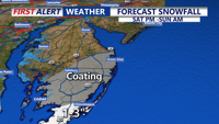
Delmarva stays locked in arctic cold today with highs only in the low to mid 20s under increasing clouds, flirting with record territory near Georgetown. Light snow and flurries arrive this evening and overnight, with the best chance for measurable snow remaining in far southern and coastal areas, especially Accomack County. The bigger story is a rapidly strengthening storm offshore that will bring bitter wind chills and the risk of minor coastal flooding during the Sunday morning high tide


Delaware Electric Cooperative is warning people to prepare for strong winds and bitter cold this weekend, even as snow totals are now expected to be lower than earlier forecasts.

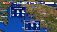
Strong winds and cold temperatures persist Tuesday before easing overnight into early Wednesday in Sussex County.

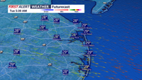
A strong cold front ushers in damaging wind gusts and frigid temperatures through Tuesday evening in Sussex County.


Mild temperatures and scattered showers move through Delmarva today ahead of a strong cold front, followed by gusty winds and a return to winterlike cold through the week.


A powerful cold front brings strong winds and sharply colder temperatures to Delmarva today, followed by quieter but chilly conditions this weekend and periodic rain chances next week.


Mild, quiet conditions today will be short-lived as rain, gusty winds and a sharp temperature drop arrive overnight into Friday.


Power companies are urging people in the area to prepare for potential outages overnight, especially if high winds cause ice-laden branches to fall.