


Sussex County will ride a mild stretch from late Friday through late Saturday evening, then brace for a colder pattern as an arctic front approaches late Saturday night into Sunday.
From
To


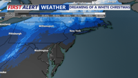
Delmarva enjoys a bright and seasonable Christmas Eve before unsettled weather arrives, including a storm system late Friday, rain late Sunday, and sharply colder conditions early next week.


Delmarva will see breezy and seasonable conditions through Christmas Day before an increasingly active and potentially wintry pattern takes shape heading into the weekend and early next week.

A departing coastal low brings steady Tuesday rain before a cold, quiet stretch settles in midweek, followed by another shot of arctic air and a possible wintry system heading into the weekend.


A winter storm will bring heavy snow, strong winds, and hazardous travel conditions to Sussex County and Ocean City from Tuesday afternoon through early Wednesday, with accumulations of 5-7 inches and locally higher amounts possible.

Will enjoy a brief thaw as the final week of January begins with seasonable temperatures and mostly dry conditions. A strong cold front midweek will usher in colder air and arctic high pressure, followed by a potentially complex system bringing precipitation into the weekend.

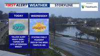
After light wintry precipitation early Tuesday, Sussex County will experience relatively calm weather through Thursday, with a gradual warming trend and clearing skies.

A weak disturbance will bring a light round of wintry precipitation to Sussex County early Tuesday, with warmer conditions expected by the afternoon.

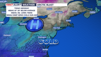
A strong Canadian high-pressure system will usher in frigid temperatures and windy conditions starting today and lasting through Monday. Wind chills will dip into the 20s today, with even colder conditions expected Sunday morning. A potential low-pressure system could bring precipitation Monday night into Christmas Eve.