


DELMARVA -- The influence of high pressure building into the Ohio Valley and Appalachian Mountains, bringing a much calmer day Friday. Winds will be lighter than previous days, around 10 mph with occasional gusts near 20 mph, and skies will stay dry.

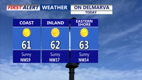
Beautiful day on Delmarva, highs in the low 60s once again, not as breezy.
Highs will reach the low 60s across most of the region. Skies remain mostly clear Friday night as winds diminish. Temperatures will dip into the upper 30s to low 40s, and while frost is not guaranteed, a few colder inland spots could see patchy frost if conditions cool slightly more than forecast. Some clouds may move in overnight, potentially limiting how cold temperatures get.

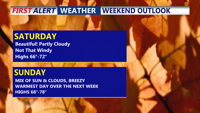
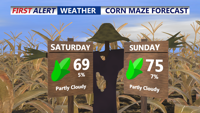
Spectacular weekend on tap, milder trend, seasonable Saturday, mid 70s and breezy Sunday ahead of a cold front.
Saturday will feature a shift in the weather pattern as high pressure slides offshore and southerly flow brings in warmer air. Afternoon highs will climb into the mid to upper 60s, with some spots nearing 70 degrees. High clouds will increase later in the day ahead of a strong cold front approaching from the Midwest. Overnight lows will be milder compared to recent nights.

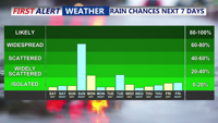
Cold front will bring rain to the area overnight Sunday-Monday morning.
By Sunday, a strong upper-level trough will swing through the Mid-Atlantic, increasing moisture and bringing temperatures into the mid-70s despite growing cloud cover. Dew points will rise as southerly winds strengthen ahead of the approaching front. Showers are likely Sunday night, and while instability looks limited, strong upper-level support could produce a narrow band of heavier showers capable of brief strong wind gusts.
The front will clear Delmarva early Monday, but lingering showers are possible as cooler air filters in behind it. A brief period of high pressure returns Monday night into Tuesday, allowing temperatures to rebound to near 70°F ahead of the next system.
Another cold front is expected Tuesday night, though precipitation chances remain uncertain. By Thursday, a larger trough over eastern Canada will usher in cooler air once again, keeping temperatures seasonable and conditions brisk into the latter part of the week.