


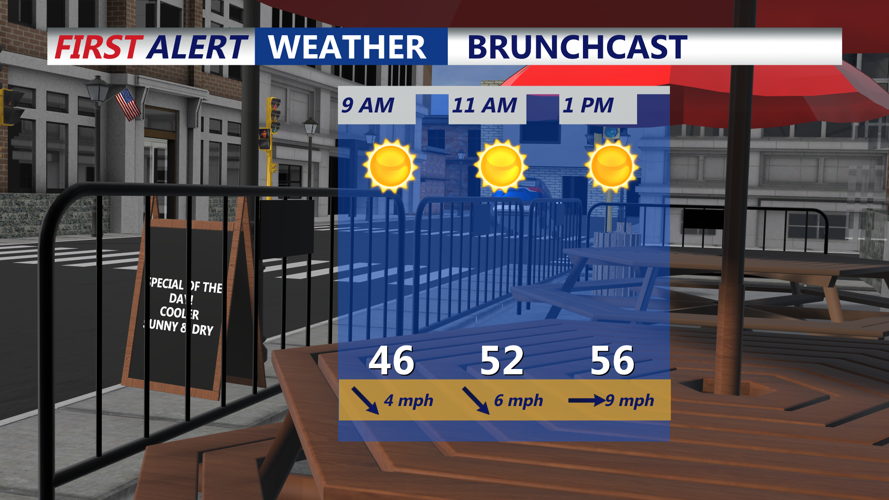


Tuesday morning starts on a bright and breezy note along the beaches of southern Delaware and into Ocean City, Maryland. Skies are partly sunny early, thanks to high pressure moving eastward just to the south. Winds from the southwest pick up by mid-morning, gusting up to 25 mph at times, especially in more exposed coastal areas like Cape Henlopen and Fenwick Island. These gusts are driven by a tight pressure gradient between the departing high and a weak area of low pressure developing upstream.
Temperatures rebound nicely with the help of that southwest flow. By late morning and into early afternoon, highs along the shorelines climb into the upper 50s to low 60s—several degrees above seasonal averages. This mild air is transported in part by low-level warm-air advection, where warmer air rides in horizontally at lower altitudes, a common setup ahead of a developing low-pressure system.
By late Tuesday afternoon and early evening, clouds begin to increase from the west as a clipper system approaches the Mid-Atlantic. This fast-moving, moisture-limited disturbance dives southeastward overnight, bringing with it a narrow band of rain. The best chances for rain are between midnight and sunrise, especially for southern Sussex County and the coastal stretch from Dewey Beach to Ocean City. While this system is weak, some showers could be steady for a brief period before sunrise.
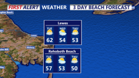
Because temperatures remain in the mid-40s along the beaches, any precipitation that falls will be strictly liquid. Inland areas may dip into the upper 30s, but not enough for a wintry mix along the coast. The clipper moves quickly, and by dawn Wednesday most of the rain will have either moved offshore or dissipated entirely.
By Wednesday morning, low clouds and patchy drizzle may hang around at the immediate coast, but a drying trend sets in by midmorning as drier air filters in behind the departing low. Winds shift slightly from the northwest and stay light to moderate, helping to mix out lingering clouds. Temperatures recover slowly, reaching into the low to mid-50s by late morning and continuing into the noon hour.
This shift marks the end of the brief unsettled spell, with improving conditions expected through the rest of the afternoon. The rapid weather transition reflects a classic early spring pattern, where clippers and weak lows move quickly under strong jet stream steering currents, while high pressure waits in the wings to bring sunshine back just as fast as clouds roll in.