


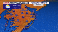


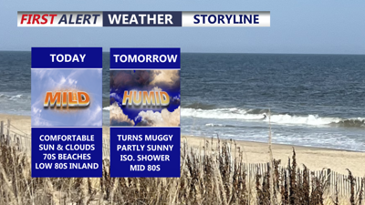
DELMARVA -- Enjoying a beautiful and comfortable day today, with temperatures climbing into the 70s and 80s and dew points holding mainly in the 50s and 60s. A mix of sun and clouds will continue through the afternoon. Along the beaches, an onshore wind will keep conditions cooler, with occasional gusts up to 20 mph.

Partly cloudy skies, comfortable humidity levels, highs in the upper 70s to low 80s.
Tonight, skies will turn partly to mostly cloudy. A stray shower or isolated ti-storm is possible. In fact The Storm Prediction Center has placed the area under a MARGINAL severe risk in the early morning hours. Damaging winds and hail are the primary threats. Patchy fog may also develop overnight as temperatures settle into the low to mid 60s.

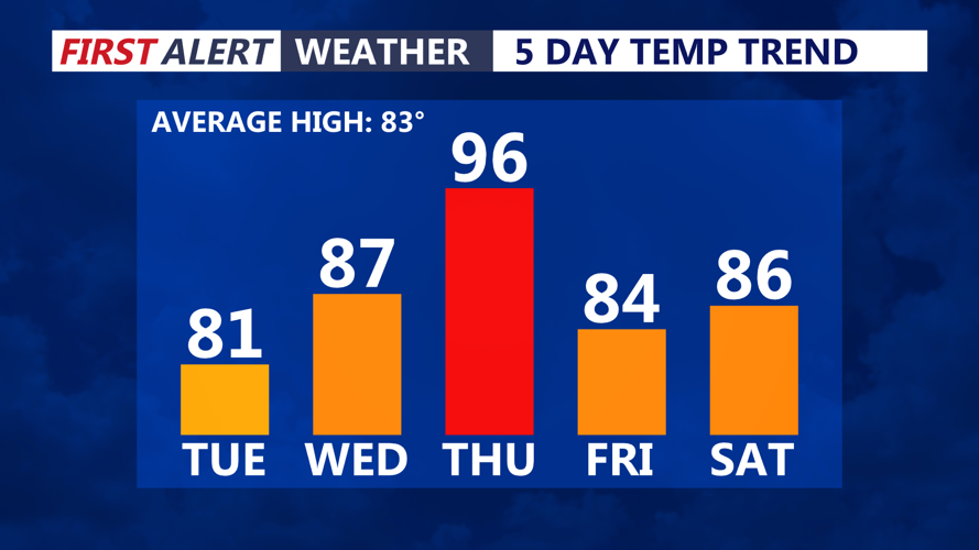
Warm front will bring the return of humidity and heat Wednesday-Thursday.
Humidity begins to rise on Wednesday as a warm front lifts through Delmarva. Highs will reach the mid to upper 80s under partly sunny skies. While much of the day looks dry, an isolated shower or thunderstorm will be possible.
Thursday is expected to be the hottest day of the week. Highs will climb into the mid 90s, with heat index values making it feel closer to 98 to 101 degrees at times. Southwest winds will also increase, with sustained winds of 15 to 25 mph and gusts potentially reaching 35 to 40 mph by Thursday afternoon and evening, even outside of thunderstorms.
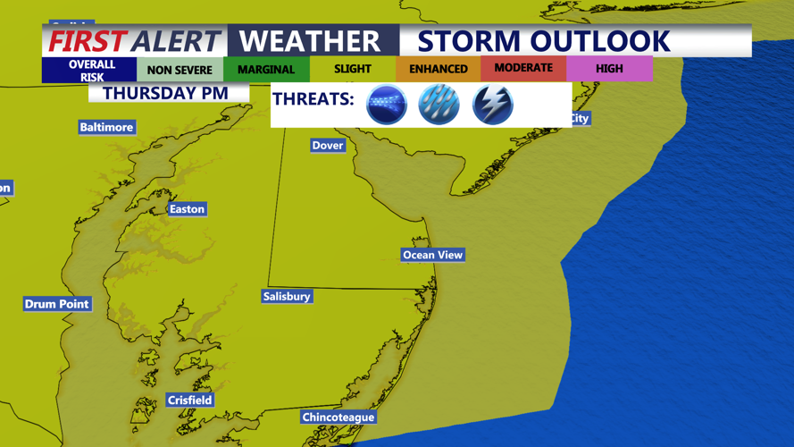
A strong cold front approaching Delmarva Thursday afternoon and evening will bring the potential for severe thunderstorms. The Storm Prediction Center has the area in a SLIGHT risk (2 of 5) for severe storms.

Slight risk (2 of 5) of severe storms, Thursday late afternoon-evening, greatest threat right now is damaging winds.
The setup will feature a warmer, more humid air mass, strengthening winds aloft, and enough instability to support strong to severe storms. Damaging winds appear to be the primary concern, especially if storms organize into a line. However, if instability and wind shear become stronger than currently expected, additional severe weather hazards could come into play.
Some showers and thunderstorms may linger into Friday as the upper-level system moves through. After that, the forecast improves just in time for the weekend.
Saturday looks fabulous across Delmarva, with mostly sunny skies and highs in the mid 80s. Father’s Day and the first day of summer arrive Sunday with partly cloudy skies and highs in the mid to upper 80s.
