


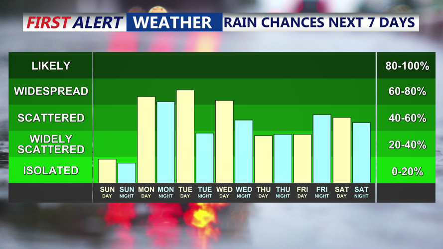
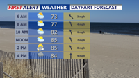


DELMARVA -- Expect partly to mostly cloudy skies tonight with muggy conditions settling in. Lows will hold in the low 70s, and areas of fog and mist will develop overnight, especially along the coastline. Motorists should be cautious of reduced visibility late tonight and early Monday morning.

Cold front stalls over the area Tuesday keep conditions unsettled.
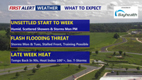
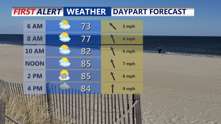
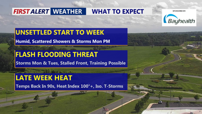
On Monday, a surface front will approach Delmarva while an upper-level disturbance moves overhead. The arrival of this front has trended slightly later in forecast models, meaning thunderstorms may hold off until late afternoon or early evening. Highs will rise into the mid 80s with oppressive humidity fueling the atmosphere.

Start Monday with some fog, mix of sun and clouds ahead of the front that will spawn scattered showers ands storms late in the day.
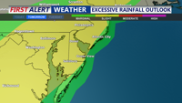
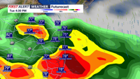
The main threat Monday will be heavy rainfall and flash flooding, especially during the afternoon and evening hours. While the severe risk remains low, any thunderstorms could produce intense downpours, frequent lightning, and isolated gusty winds. A small chance exists that precipitation-loaded cells could develop wet microbursts, briefly enhancing wind gusts near stronger storms.

Flash flooding is possible Monday and Tuesday with slow moving training thunderstorms.
The cold front is forecast to stall over the region through midweek. Although a mid- and upper-level ridge will attempt to build eastward from the southwest, uncertainty persists on how quickly it will suppress additional storm development.
Scattered showers and thunderstorms will remain possible Tuesday and Wednesday, primarily during the afternoon and evening hours.

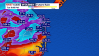
Heavy drenching downpours Tuesday may train producing a flash flooding threat.
Any storms could again bring locally heavy rainfall. With high moisture levels in place, isolated flash flooding remains a concern. Overnight lows will stay muggy, in the low to mid 70s, while daytime highs climb into the mid to upper 80s. Patchy fog could redevelop late at night, depending on earlier rainfall and overnight mixing.

Between Monday night and Tuesday night 1 to 3 inches of rain is possible with locally higher amounts.
Looking toward Thursday and Friday, attention shifts to building heat. Warm, humid air will persist, and heat index values could approach or exceed 100 degrees for much of Delmarva, especially inland areas. Another cold front approaching at week’s end may spark more widespread showers and storms.
This unsettled pattern highlights the importance of monitoring forecast changes. Flash flooding is the primary concern Monday and Tuesday, with the potential for rapid rises in water over poor drainage and urban areas. Later in the week, dangerous heat will take center stage.
