


DELMARVA -- A pleasant Memorial Day as high pressure builds in from the north and west, clearing skies this afternoon. Expect mostly sunny skies, calmer winds, and highs in the low 70s inland, with upper 60s near the coast. Winds will be light enough to allow a sea breeze to develop.
Conditions remain fair into Monday night and Tuesday morning. A rather cool start Tuesday morning with some inland locations dipping into the upper 40s.
As surface high pressure moves offshore Tuesday afternoon, cloud cover will gradually increase. Temperatures will continue running slightly below average, with highs in the low 70s and comfortable overnight lows in the 50s.

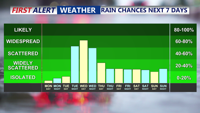
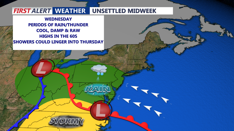
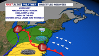
By Tuesday night, moisture begins to push into the region from the southwest as onshore flow strengthens. Skies will become overcast, setting the stage for a cloudy and wet Wednesday. Rain associated with an approaching warm front is expected to arrive from southwest to northeast during the day, bringing steady rainfall to much of the area.

Rainfall totals on Wednesday could range from one-half to three-quarters of an inch across Delmarva, with lower amounts toward the northeast. A few thunderstorms are possible later in the day, adding to the potential for brief heavier downpours. Highs on Wednesday will be held down by the cloud cover and rain, with most areas only reaching the 60s.
The unsettled pattern continues through the second half of the week as an upper-level trough and low pressure system over the Great Lakes move east. The best chance for additional rain and thunderstorms will be Wednesday night, followed by scattered showers Thursday. We start to dry out on Friday with temperatures in the 70s.
By Saturday, another cold front is expected to sweep through, bringing another round of rain chances—particularly in northwestern areas where precipitation probabilities are around 50 percent. Southeastern areas will see lower chances near 25 to 30 percent.