


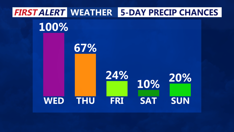

DELMARVA - Rainy, breezy, and unseasonably cool conditions are expected to persist from early Wednesday through early Friday across Sussex County and surrounding beach towns, as a complex storm system takes shape along the East Coast.
Wednesday: A Wet Start with Building Winds
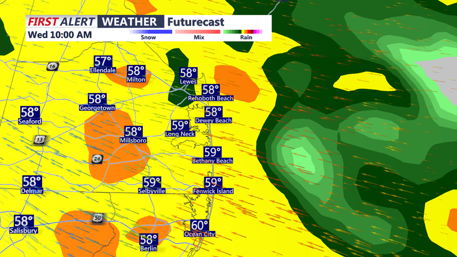
Rain will be widespread across the region by Wednesday morning as a low-pressure system in the Ohio Valley begins to weaken and a new surface low develops offshore. The area will remain under thick cloud cover, with periods of steady rain continuing throughout the day. Despite occasional breaks—especially in southern portions of the county—most locations will experience persistent damp conditions.
Temperatures will remain well below normal, with highs struggling to climb out of the 50s. An easterly wind will gradually intensify through the day, pushing in cooler marine air and enhancing rainfall rates at times.
Wednesday Night: Rain May Intensify with Coastal Low Nearby
By Wednesday night, the newly formed coastal low will strengthen and move northward off the Mid-Atlantic coast, bringing a renewed surge of moderate to heavy rainfall, particularly across coastal Sussex County. Rainfall totals could exceed 1 inch in many locations, with localized amounts up to 1.5 inches possible. Coastal areas will also be vulnerable to periods of heavier rain, thanks to enhanced lift from an incoming low-level jet.
While the majority of the region will see just rain, some elevated instability could trigger an isolated thunderstorm in the Delmarva area Wednesday evening, though this threat remains limited.
Winds Ramp Up Late Wednesday into Thursday
Gusty easterly winds will continue to build, especially along the coast, where wind gusts of 30 to 40 mph are likely. These strong winds may lead to coastal flooding in low-lying areas and contribute to choppy seas and dangerous surf conditions. By Thursday, winds will gradually shift to the north and northwest as the storm system pulls away, but breezy conditions will linger.
Thursday: Continued Showers and Unseasonably Cool
Rain is expected to continue through much of Thursday, particularly during the morning hours. Showers may become more scattered in the afternoon as the coastal low moves farther north. Despite the easing precipitation, thick cloud cover and lingering northerly winds will keep daytime temperatures well below average, with highs again in the upper 50s to low 60s.
Early Friday: Damp Start Before Gradual Improvement
By early Friday, the storm system will begin to exit the region. A few showers may linger into the early morning hours, but drier air should gradually work in from the west. Although skies may remain mostly cloudy to start the day, a gradual clearing trend is expected by midday. Winds will also ease, and temperatures will begin a slow rebound heading into the Memorial Day weekend.