


DELMARVA --A powerful cold front sweeping through Delmarva on Saturday will bring a significant cooldown, with temperatures quickly falling through the 40s and into the 30s. Strong west-northwest winds will continue into the evening, with gusts reaching 35 to 40 mph. Wind chills will drop into the teens and low 20s by early Sunday morning, making for a bitterly cold start to the day.

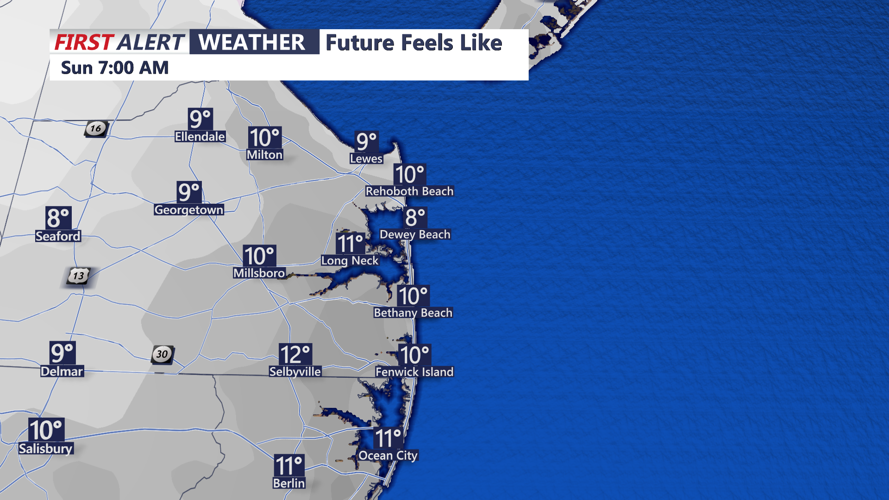
Bitter wind chills will greet you Sunday morning.
High pressure will build in behind the front, keeping skies mostly clear on Sunday. However, temperatures will struggle to climb, with highs only reaching the mid-30s. Brisk winds will persist, keeping wind chills well below freezing. By Sunday night, lows will drop into the teens and low 20s, marking one of the coldest nights of the season.
Monday will bring similar conditions, though winds will begin to ease. Highs will creep into the upper 30s to low 40s, with mostly sunny skies. By Monday night, winds will shift to a more southerly direction, allowing for some moderation in temperatures.
By Tuesday, a developing storm system in the central U.S. will begin to influence Delmarva's weather. Highs will rebound into the 50s as cloud cover increases. By late Tuesday night or early Wednesday, rain showers will begin to move into the region.
The main event arrives Wednesday afternoon and evening as a strong cold front approaches. While details remain uncertain, the system is expected to bring heavy rain, strong winds, and possibly some severe thunderstorms. Wind advisories may be necessary, as gusts could reach damaging levels. Temperatures may surge into the 60s ahead of the front, which could enhance the risk for severe weather.
Conditions will improve Thursday as high pressure returns, but another blast of cold air will follow behind the storm.
