


DELMARVA -- What a difference a day makes. After enjoying a summery Saturday with temperatures peaking in the mid-80s and a distinctly humid air mass, Delmarva is in for a significant change as a strong cold front sweeps through the region Saturday night.

NWS Mt. Holly confirms a tornado touched down just south of Bethel, DE Friday evening.
On Saturday the National Weather Service in Mt. Holly CONFIRMED a tornado touched down just south of Bethel, DE on Friday evening. A survey team was out on Saturday. Further information as to the exact max winds and track will be released Sunday.

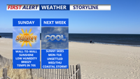
Sunny and lower humidity Sunday, turns unsettled midweek.
The front will bring noticeably cooler and drier air, dropping overnight temperatures into the low to mid-60s. Partly cloudy skies and falling humidity will set the stage for a sensational Sunday.
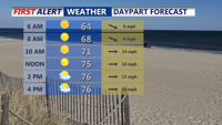
Sunday’s weather will be a standout, with abundant sunshine across the region. Inland temperatures are forecast to reach between 75 and 81 degrees, while coastal areas will see highs ranging from 72 to 77. It will be breezy, with west winds gusting between 25 and 35 mph during the afternoon.

Wall-to-wall sunshine with highs in the mid to upper 70s.
A secondary cold front will pass through the area Sunday night, reinforcing the cool and dry conditions. High pressure will build in behind the front, dominating the weather pattern through Tuesday. This period will feature mostly clear skies, crisp nights, and comfortable daytime highs — upper 60s to low 70s across much of Delmarva. Overnight lows will dip into the 40s and 50s, signaling a true taste of fall.
Winds will remain breezy through early Monday, with gusts up to 30 mph, before calming Monday night into Tuesday. Overall, the early part of the week is expected to be dry and tranquil.

Potential coast low could impact Delmarva Wednesday-Thursday.
However, changes are on the horizon by midweek. Starting Tuesday night, a new weather system will approach from the west. A deepening upper-level trough over the Great Lakes will trigger a series of low-pressure systems, one moving inland and another forming off the Mid-Atlantic coast.
Rain chances will increase significantly by Wednesday and Thursday, with the potential for heavy rainfall at times. Forecast models currently suggest a 50 to 80 percent chance of rain during this period. Even as the rain diminishes late Thursday into Friday, scattered showers may linger under the influence of the upper-level trough. Temperatures during this stretch will trend below normal.