


DELMARVA - Residents of Sussex County should prepare for another round of unsettled weather conditions beginning late Tuesday and continuing through late Wednesday evening.
Any showers and storms developing Tuesday afternoon are expected to diminish near sunset as daytime heating wanes. However, a few lingering showers could persist overnight. Skies will start mostly clear, but clouds are forecast to increase after midnight as low stratus clouds develop. Temperatures will remain warm overnight, with lows mainly in the 70s.
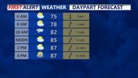
By Wednesday, a stalled frontal boundary will begin lifting northward, setting the stage for several rounds of showers and thunderstorms. While the exact placement of the front remains uncertain, the combination of warm, humid air and weak synoptic forcing will allow scattered to numerous storms to redevelop during the afternoon and evening hours.
The primary hazard through Wednesday will be locally heavy rainfall that could cause flash flooding, particularly in poorly drained areas. Although no severe weather outlook has been issued, isolated damaging wind gusts cannot be ruled out in stronger storms.
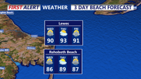
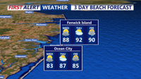
Persistent southerly flow will maintain high humidity and push temperatures into the upper 80s and low 90s. Heat index values may approach 100 degrees, especially on Thursday if the expected cold front remains delayed. Forecasters caution that a Heat Advisory may be necessary for parts of the area if extreme heat persists.
Residents are encouraged to monitor updated forecasts and remain alert for any flood advisories or warnings that may be issued as the weather system evolves.