


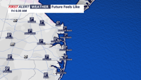


DELMARVA -- Frigid night on tap as an arctic high-pressure system settles over the region. Temperatures will dip into the upper teens to low 20s, with wind chills in the single digits and teens by Friday morning. Clear skies and breezy conditions will prevail overnight, creating slick spots on roads and bridges due to refreezing.

Single digit wind chills Friday morning
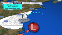
Friday will bring quieter but cold weather, with highs in the low to mid-30s and lighter winds. However, the calm won’t last long as a low-pressure system tracking from the Gulf of Mexico approaches Friday night. Snow is expected to begin after midnight, moving from southwest to northeast across the region.

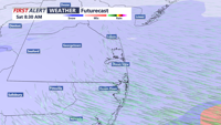
Light to moderate snow by Sunday morning
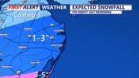
Snow accumulations will range from a coating to an inch for most areas, with 1 to 2 inches possible across Delmarva. A Winter Storm Warning is in effect for Accomack County, where totals could reach 3 to 5 inches. Sussex County may also see isolated spots with up to 3 inches of snow.

Expected snowfall through Saturday afternoon
Precipitation will taper off by Saturday afternoon, but winds will increase, gusting up to 30 mph. Daytime highs will remain in the upper 20s to mid-30s, with wind chills making it feel much colder.
High pressure will return Sunday, bringing calmer winds and slightly milder temperatures in the upper 30s to around 40 under partly sunny skies. However, the break in the cold will be brief. A reinforcing shot of arctic air arrives Tuesday into Wednesday, keeping high temperatures below freezing and overnight lows in the teens. Wind chills could dip into the single digits during the middle of next week.