



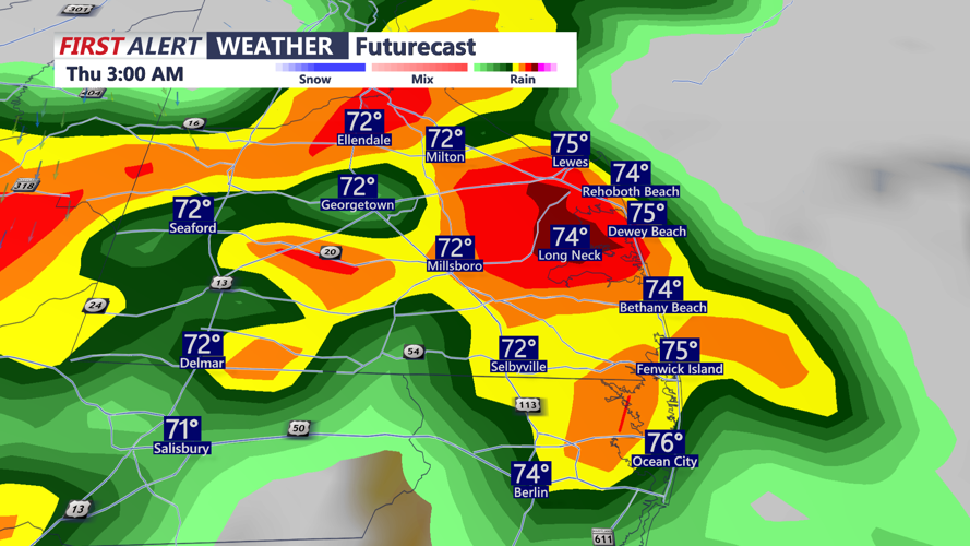

DELMARVA - Unsettled weather will continue across Sussex County late Wednesday evening and overnight, with another round of showers and thunderstorms possible as a disturbance moves through the region.
Confidence in how widespread or intense the storms become remains relatively low because a stable layer of marine air could limit development. However, if the atmosphere becomes more unstable, some storms could become strong to severe. Damaging wind gusts, hail and an isolated tornado would be possible. Locally heavy rainfall could also occur, especially where storms repeatedly move over the same areas.
Conditions will turn hotter and more humid Thursday as a frontal boundary lifts north of the region. Afternoon highs across Sussex County are expected to climb into the upper 80s to lower 90s, with dew points in the low to mid-70s.
The combination of heat and humidity could push heat index values close to 105 degrees in parts of Delmarva. A Heat Advisory has been expanded into the region because of the potentially dangerous heat.
Thunderstorms could develop again Thursday afternoon and evening. Sussex County is included in a Slight Risk, level 2 out of 5, for severe thunderstorms.
The atmospheric pattern will support the potential for damaging winds, large hail and isolated tornadoes. Localized flooding cannot be ruled out where repeated thunderstorms produce heavy rain over the same locations.
Additional scattered showers and thunderstorms will remain possible Friday, especially across southern Delaware and the Maryland Eastern Shore.
A major change arrives for Labor Day weekend as the front moves south and Canadian high pressure builds into the Mid-Atlantic. Mostly dry weather, lower humidity and temperatures near or slightly below normal are expected for the holiday weekend.
