


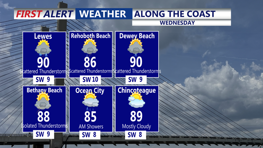


DELMARVA - Sussex County residents will contend with unsettled weather and intense summer heat from early Wednesday morning through early Friday.
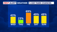
Starting Wednesday, a stalled frontal boundary lifting north across the region will trigger multiple waves of showers and thunderstorms. While the precise location of the front remains uncertain, warm and moisture-laden air combined with daytime heating is expected to support scattered to numerous storms both Wednesday and Thursday.
Periods of locally heavy rainfall could lead to flash flooding in vulnerable areas, especially during stronger storms. Although widespread severe weather is not anticipated, the possibility of isolated damaging wind gusts exists.
Wednesday will feature high temperatures climbing into the upper 80s and low 90s, with sticky humidity pushing heat index values well into the 90s. Overnight lows will stay warm, mainly in the mid- to upper 70s. Clouds and pockets of rain may linger into Thursday morning before additional rounds of convection redevelop later in the day.
Thursday is forecast to be the hottest day of the week. Southwesterly winds will draw in even warmer air, with heat index readings potentially reaching or exceeding 100 degrees. Forecasters are monitoring conditions closely and note that a Heat Advisory could be issued if extreme heat continues to build.
By Friday, a cold front will approach from the west. The timing of this boundary remains uncertain, but it may cross the area late Friday or Friday night. If the front arrives later than projected, heat and humidity could persist into much of Friday. The front will also act as a focus for additional thunderstorms, which could again bring heavy rainfall and gusty winds.
Residents are advised to remain aware of rapidly changing weather conditions, especially during afternoon and evening hours when storms are most likely to form. Heat safety precautions are also strongly encouraged to avoid heat-related illness.