


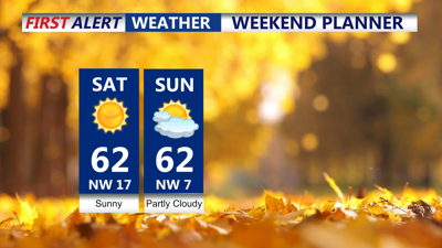
DELMARVA -- High pressure building eastward from the central U.S. will dominate the weather pattern, ensuring sunny skies across the Delmarva Peninsula today. High temperatures will range from the upper 50s to low 60s, about 5 to 7 degrees above average for this time of year.
Winds will turn brisk by late morning, coming from the northwest at 15–20 mph with gusts reaching 25–30 mph. These gusty winds, combined with dry conditions and low humidity, create an elevated risk of fire activity across the region, particularly in Delaware. Although no official red flag warnings are in place, residents should avoid outdoor burning.

Conditions are there for fires across Delaware today
Coastal flooding remains a concern along the Atlantic coastline, as a combination of persistent shore-parallel winds, high astronomical tides, and a recent full moon continue to exacerbate water levels. A Coastal Flood Advisory is in effect for the Delaware, Maryland, and Virginia coasts through this afternoon. While astronomical tides are expected to gradually decrease this weekend, minor tidal flooding is still likely during high tide cycles.
Winds will diminish as high pressure moves closer, leading to calmer conditions overnight. Clear skies and a dry air mass will allow temperatures to drop quickly after sunset, with lows near freezing inland and slightly warmer temperatures in urban areas and along the coast.
Tomorrow will be another pleasant day, with highs similar to or slightly warmer than Saturday, reaching the low to mid-60s. Winds will be lighter, and sunshine will dominate during the daytime hours. However, by late Sunday, a weak cold front associated with a passing upper-level trough will bring some clouds into the region. Despite the front’s arrival, no precipitation is expected, and temperatures will remain mild.
Overnight lows Sunday into Monday will hover in the upper 30s to low 40s, thanks to added cloud cover. By Monday, sunshine returns as the front exits offshore, with highs climbing well into the 60s. The warming trend will continue into Tuesday, setting up for an above-average start to the workweek.

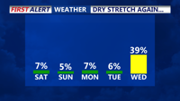
Rain moves back into the area late Wednesday.
A pattern change midweek could bring increasing cloud cover and a chance for precipitation as a strong trough develops across the eastern U.S. This system may usher in cooler temperatures by the latter half of the week, but details remain uncertain.
