


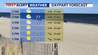


DELMARVA -- Sunday afternoon delivers —sensational sunshine, refreshing breezes, and just-right temperatures. Inland areas saw highs ranging from 75 to 81 degrees, while coastal communities enjoyed pleasant conditions in the low to mid-70s. The day was punctuated by gusty west winds, with speeds reaching 25 to 35 mph, adding a brisk and invigorating touch.

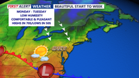
Beautiful Sunday on Delmarva with highs in the mid to upper 70s, low humidity and comfortable through the evening.
This stretch of fair weather comes courtesy of a cold front moving through the region Sunday evening. It will be followed closely by a secondary front Sunday night, ushering in even cooler, drier air for the start of the workweek. High pressure will build in from the north, keeping skies mostly clear and conditions dry through Tuesday.
Monday and Tuesday will feature a continuation of this calm and comfortable pattern. Highs on Monday will generally hold in the 70s, with a mix of 60s and 70s forecast for Tuesday. Overnight lows will dip into the 40s and 50s, giving Delmarva its first consistent taste of autumn. Breezy conditions may linger into early Monday, with gusts near 30 mph, before tapering off by Tuesday.
However, this peaceful pattern won’t last through the week. By Tuesday night, attention turns to a strengthening upper-level trough developing over the northern Great Lakes. This system is expected to pivot and deepen as a potent disturbance rounds its base midweek, setting the stage for an active stretch of weather.

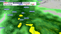
A midweek soaking is possible from a coastal low that could develop.
Surface-level low pressure is forecast to form over the Ohio Valley on Wednesday and track into the eastern Great Lakes. Simultaneously, a secondary coastal low is expected to develop just off the Mid-Atlantic coast by Wednesday night, intensifying as it moves into New England Thursday.
These combined features will bring increasing rain chances to Delmarva starting late Tuesday. The heaviest rainfall is currently expected between Wednesday and Thursday, with rain possibly falling at a steady or heavy pace. The National Blend of Models now suggests a 50 to 80 percent probability of precipitation for that timeframe.
Rain may taper slightly by Thursday night into Friday, though scattered showers are still likely as the region remains under the influence of the lingering upper trough. Temperatures will trend below normal during this stretch, reinforcing the arrival of a more autumn-like pattern as the Memorial Day Weekend approaches.