




DELMARVA -- Tonight into Friday, an upper-level shortwave moving eastward from the Ohio Valley and Great Lakes will bring a slight increase in instability, leading to scattered showers and possibly a few isolated thunderstorms.
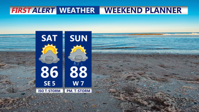
Friday will be mostly cloudy and a few breaks of sun with temperatures staying cooler in the low 80s to 70s at the coast, after overnight lows in the 60s. Still a bit breezy at the coast with that east wind at about 10-15mph. Friday night, the stalled front to our south will begin to lift northward as a warm front, bringing a chance of isolated showers and thunderstorms into Saturday morning. This front could bring stronger thunderstorms, especially if it arrives during peak daytime heating. So will monitor that closely heading into the weekend.
As the first cold front moves through, another secondary cold front will follow late Sunday into Sunday night. This will bring another round of showers and storms, although these should be more scattered in nature due to some drying in the upper atmosphere. By Labor Day, high pressure will build in, bringing cooler and drier conditions to the area for the start of the week.
Temperatures over the weekend will be around average for this time of year, with highs in the 70s and low 80s and warmer than average lows, particularly Saturday night. By Sunday night, temperatures will drop below average as the cooler air mass settles in behind the secondary cold front.
