


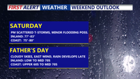
Bracing for a soggy, cooler-than-normal weekend as a stalled front brings multiple rounds of rain and thunderstorms through early next week. Though severe weather isn't expected, intermittent downpours could lead to minor flooding. A slow warming trend will begin midweek as Bermuda high pressure builds in, eventually bringing back summer-like conditions.
From
To

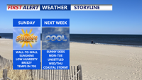
Sunday promises to be a picture-perfect day across Delmarva with sunny skies, comfortable temperatures, and refreshing breezes. A pair of cold fronts will bring crisp, dry air into the region through Sunday night, paving the way for a calm and cool start to the week. High pressure will dominate Monday and Tuesday with clear skies and seasonal temperatures, but by midweek, a more unsettled weather pattern returns. Rain is expected Wednesday into Thursday, with cooler-than-normal temperatures prevailing into the weekend.


Sussex County Prepares for Temperature Swings and High Winds

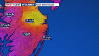
Sussex County, Delaware, and Ocean City, Maryland, will experience lingering gusty winds on Friday before high pressure brings calmer conditions and gradually warming temperatures through Sunday.

The Delmarva region will experience gusty winds, below-normal temperatures, and biting wind chills from Tuesday evening through Wednesday, with conditions gradually improving by the end of the week.

A cold front will clear the Delmarva region tonight, ushering in the coldest air mass of the season. Temperatures are expected to drop into the mid to upper 20s, with wind chills falling well below freezing. High pressure will bring dry but chilly conditions for Saturday, with wind chills making it feel like the 20s. A weak disturbance Sunday night could bring light snow or mixed precipitation to parts of the region.

Low pressure will linger across the Middle Atlantic tonight, bringing light rain and windy conditions to Delmarva. The system will gradually pull away this weekend, allowing for partial sunshine and seasonable temperatures. A dry and milder stretch will follow Sunday into early next week before a cold front moves through Monday night. Looking ahead, a low-pressure system could bring wet weather around Thanksgiving.


Expect a warm, mostly sunny day across Delmarva today with temperatures reaching the upper 70s to low 80s inland. A cold front will arrive late Sunday, bringing cooler temperatures, gusty winds, and dry conditions through midweek. Keep an eye on the sky as well: Comet C/2023 A3 Tsuchinshan-ATLAS will be visible low on the western horizon after sunset, offering a rare opportunity for stargazers.

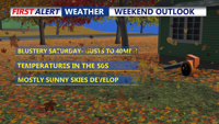
As Fall begins, Delmarva will experience a range of weather conditions, starting with a chance of showers on Sunday morning, followed by a mix of sun and clouds through the early week. Temperatures will remain mild, with highs in the 60s and 70s, but a more unsettled pattern is expected from Tuesday night onward, bringing increased chances of rain.

High pressure will dominate Delmarva's weather through the week, leading to clear skies and mild temperatures. A sea breeze might develop this afternoon but will have minimal inland impact. Overnight, temperatures will be cooler than normal due to radiational cooling, with some high cirrus clouds possible. The rest of the week will remain dry and calm, with temperatures gradually rising above average by the weekend before returning closer to normal early next week.