


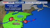


DELMARVA -- Friday night marks the beginning of an unsettled stretch of weather across the Delmarva Peninsula, a stalled frontal boundary will bring multiple waves of low pressure and repeated rounds of rain and thunderstorms through early next week.

Stalled front will bring on and off showers and storms through Father's Day weekend.
We had a brief severe thunderstorm warning across portions of SE Sussex County late this afternoon, brough torrential downpours and hail.
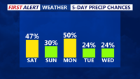
The first round of showers is expected to arrive late Friday night, especially after midnight, as a weak low pressure system passes just south of the region. Showers and scattered thunderstorms will linger through Saturday morning. Mid-level atmospheric instability will be low, minimizing the risk of severe storms. However, periods of locally heavy rainfall could occur, though flooding concerns remain limited. Overnight lows will dip into the upper 60s to low 70s Friday night with some areas of fog.

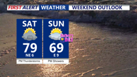
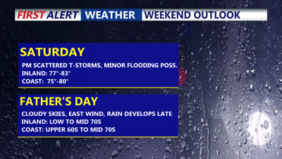
Scattered showers and storms Saturday, humid, overcast Father's Day with PM showers and storms.
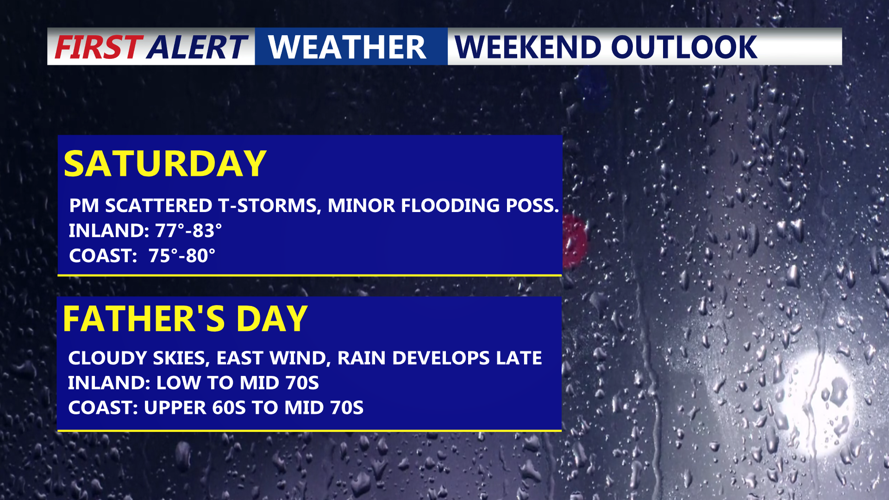
Saturday may bring a brief midday reprieve from the rain before a second round of showers and storms develops by afternoon and evening, accompanying the passage of a more defined low-pressure system. Precipitable water values (PWATs) between 1.7 and 2.0 inches may lead to heavier rainfall and isolated areas of minor flooding, especially in low-lying or poorly drained areas.
Daytime highs on Saturday are forecast to reach the 70s across much of Delmarva, with some areas possibly nearing 80 degrees.

Rain chances are expected through the start of next week.
A dreary pattern continues into Sunday and Monday, with persistent cloud cover, scattered showers, and cooler temperatures lingering as additional shortwaves ripple through the region. Highs on Sunday will likely remain in the mid-60s to near 70, depending on how far south the front presses and the strength of any onshore flow.
By Sunday night into Monday, a more pronounced upper-level trough could boost shower activity once again. Even so, the period remains low in predictability, with timing and coverage of showers still uncertain.
Conditions are expected to gradually improve beginning Tuesday as the weekend front moves offshore. While another weak disturbance could trigger isolated precipitation Tuesday evening, forecasters anticipate a modest warming trend. Southeast winds and increasing sunshine will help push temperatures back into the mid-70s to low 80s.
By Wednesday and Thursday, a strengthening Bermuda high offshore will reintroduce a southwest flow across Delmarva. Temperatures will rise into the 80s midweek, with some locations nearing the 90-degree mark by Thursday. A few late-day storms are possible ahead of an approaching cold front expected to sweep through late Thursday. Behind it, Friday looks to be drier and seasonably warm.