


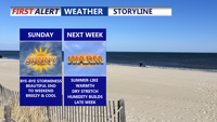
Severe storms, heavy rain and tropical humidity will persist through late Thursday evening as a slow-moving front wobbles across the region.
From
To

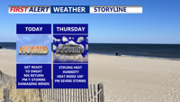
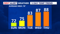
Delmarva faces an intense burst of summer weather beginning Wednesday, with highs soaring into the 90s and heat indices nearing 100 degrees. Widespread thunderstorms—some potentially severe—are likely late Thursday. A cold front will usher in more comfortable, drier air for the weekend, though hot temperatures return early next week.


A stalled front will keep beach areas cool and damp into Tuesday while inland Sussex County sees a transition to warmer, more humid conditions with afternoon storm chances.

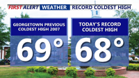
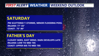
Father’s Day on Delmarva was one for the weather record books—Georgetown set a new daily cold high mark of 68°F, the third chilliest Father’s Day on record. Overcast and cool conditions linger through Monday with scattered drizzle and showers possible. A slow transition to a warmer and stormier pattern begins Tuesday, peaking Thursday with near-record heat and a risk of severe storms. Cooler, more settled weather returns for Friday and the weekend.

Rounds of showers and scattered thunderstorms as a stationary front lingers across the region. Locally heavy rain is possible, though widespread flooding is not expected. The dreary pattern will persist through Monday with cool, cloudy, and damp conditions. A gradual warmup begins midweek as Bermuda high pressure builds, eventually pushing temperatures back into the 80s and 90s by Thursday, with continued chances for afternoon storms.

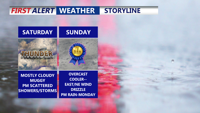
Delmarva will see rounds of showers and storms due to a stationary front stalled across the region. While locally heavy rain is possible, the risk of severe weather remains low. Temperatures will be below normal through early next week, with cloudy and drizzly conditions lingering. A midweek shift in the weather pattern will bring rising temperatures and a return to summer-like warmth by Wednesday, ahead of a cold front later in the week.

Bracing for a soggy, cooler-than-normal weekend as a stalled front brings multiple rounds of rain and thunderstorms through early next week. Though severe weather isn't expected, intermittent downpours could lead to minor flooding. A slow warming trend will begin midweek as Bermuda high pressure builds in, eventually bringing back summer-like conditions.

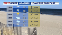
Sunday afternoon brings sunshine, cool temperatures, and breezy west winds across Delmarva. High pressure will dominate the region into midweek, leading to gradually warmer days and a potential return of summer heat by Thursday.

Sunday brings a refreshing start to June on Delmarva, with dry conditions, cool temperatures, and a light breeze. High pressure will dominate the region through midweek, setting the stage for a warming trend that could bring the first 90-degree day of the year by Thursday.

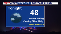
Storms have come to an end, clear and chilly night on tap as some areas away from the coast fall into the 40s. Bright, beautiful, breezy end to the weekend, summer-like next week as we make a run at our first 90 degree day of the year.