


Scattered strong storms are possible across Delmarva today, but Tuesday is expected to bring the greatest threat for severe weather and flash flooding.
From
To


Delmarva will enjoy one more pleasant and mostly sunny day Monday before humidity, showers and strong thunderstorms return Tuesday.


Delmarva will see a cloudy and humid day today as a warm front lifts north, bringing scattered showers and thunderstorms late this afternoon into tonight. A few storms could produce damaging wind gusts and heavy downpours. Dangerous heat and humidity build Thursday and Friday, with heat index values potentially reaching 95 to 104 degrees and additional severe storm chances.


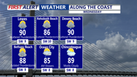
Showers and thunderstorms could bring heavy rain and gusty winds to Sussex County from late Tuesday night through Wednesday evening.

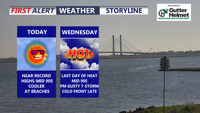
Delmarva will stay hot, sunny and dry today as southwest winds continue to push early-season heat into the region. Georgetown could approach or break a daily record high, while Delaware beaches will remain cooler but breezy. A Code Orange Air Quality Alert is in effect for Delaware today through Wednesday, and there is a moderate risk of dangerous rip currents at Delaware beaches. One more very hot day is expected Wednesday before a cold front brings showers and thunderstorms, with isolated strong to severe storms possible. Cooler, unsettled weather is expected late week into Memorial Day weekend.


Today starts a much calmer pattern across Delmarva after several days of wild weather that included temperature swings, record highs, and accumulating snow. Skies will be mostly sunny with highs in the upper 40s to low 50s, though gusty south winds will ramp up this afternoon and evening to 35 to 40 mph. The weekend looks pleasant, with sunshine Saturday, more clouds Sunday, and temperatures warming into the upper 50s, 60s, and eventually near 70 by Monday ahead of a powerful cold front. That front could bring strong to severe thunderstorms Monday afternoon and evening, along with heavy rain and damaging wind gusts, before much colder air rushes back in for Tuesday and Wednesday.

From early Wednesday through early Friday, Sussex County will face repeated rounds of showers and thunderstorms along with oppressive heat and high humidity.


Starting Monday, Delmarva will enter a prolonged stretch of hot, humid, and stormy weather. The remnants of Tropical Storm Chantal will bring widespread showers and thunderstorms capable of downpours and localized flooding. Even the threat for severe storms Tuesday. As the week progresses, a stalled front and several disturbances will prolong unsettled conditions, with dangerous heat indices nearing 106 degrees and repeated rounds of storms expected into the weekend


Beginning Sunday night, Delmarva will enter a period of high humidity and unsettled weather. The remnants of Tropical Storm Chantal will bring rounds of showers and thunderstorms Monday and Tuesday, with locally heavy rainfall and potential flash flooding. Severe storms possible Tuesday afternoon/evening. A stalled cold front will keep the region stormy through late week, while oppressive heat and humidity push heat index values to near 106 degrees.


A stalled front lifting north will trigger rounds of thunderstorms across Delmarva starting Monday and lasting into Tuesday night. With temperatures climbing into the upper 80s to low 90s and abundant moisture, the atmosphere will become increasingly unstable. Forecast models point to a heightened risk of damaging wind gusts and localized flash flooding, especially Tuesday, when a Slight Risk for severe weather has been issued. Quieter and more pleasant weather is expected to settle in by midweek and continue through the Fourth of July holiday weekend.