


Delmarva will see a dry and gradually warming forecast beginning today, with inland temperatures in the 70s and cooler conditions along the coast. A high risk for dangerous rip currents continues from Delaware beaches south to Ocean City and Chincoteague. High pressure keeps the region dry through the end of the week, with some locations potentially reaching the low 90s by Friday and Saturday.
From
To


The Delaware River and Bay Lighthouse Foundation is responsible for the structure, including maintenance, painting and repairs. This Ties That Bind Us is sponsored by Matt The Carpet Guy.


Today stays warm and sunny across Delmarva, but temperatures step down from yesterday’s record highs. Cooler air arrives near the coast Saturday as a backdoor front pushes in, while inland areas stay milder. Minor tidal flooding is expected along the Delaware coast and Delaware Bay Saturday evening into Saturday night, followed by showers, a few thunderstorms, and a sharp cool down late Saturday night into Sunday. Much colder air settles in early next week, with widespread frost or freeze conditions likely Monday night into Tuesday morning.

A new partnership between Sussex County Emergency Management and a Rehoboth Beach hotel is helping strengthen emergency communications along the Delaware coast.


Delmarva stays seasonably cool today before an arctic front brings dangerous subzero wind chills overnight, followed by a major winter storm with snow, sleet and freezing rain from Saturday night into early Monday afternoon.


A dead whale was spotted off the coast of Bethany Beach on Thursday.

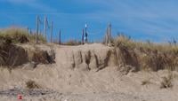
The Delaware Department of Natural Resources and Environmental Control is expected to repair Bethany Beach crossover access points that have been severely damaged during two recent coastal storms.


Major Hurricane Melissa has rapidly intensified into a Category 4 storm in the central Caribbean and while its present direct threat is to Jamaica and Hispaniola, interests including Sussex County Delaware must monitor potential northeastward motion.


The nor’easter that swept through Delmarva over the weekend took a bite out of Delaware’s coastline.


The Sussex Conservation District said it has reached a milestone in its coastal migration planning initiative, a multi-year effort to help landowners prepare for the impacts of sea level rise saltwater intrusion and habitat loss in Delaware’s tidal areas.