


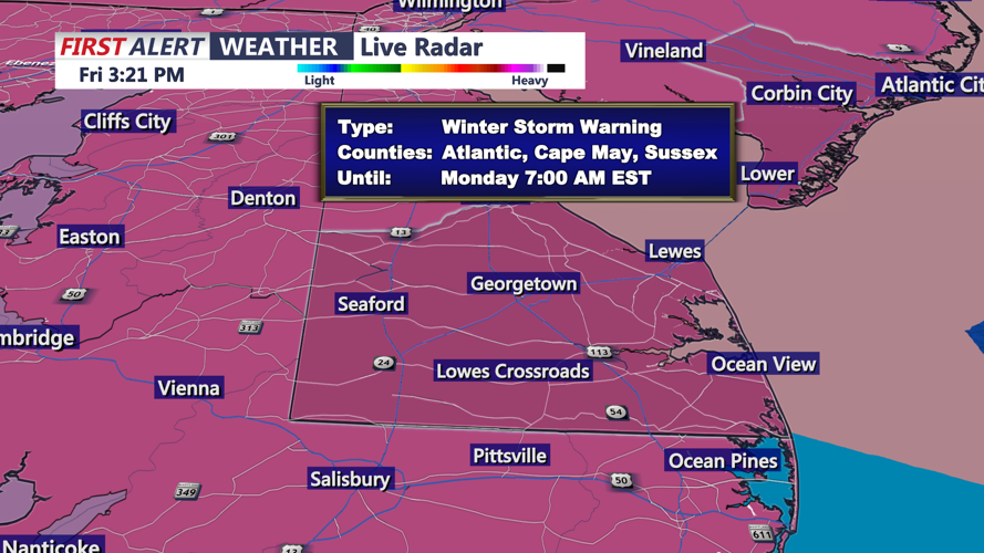


DELMARVA — A Winter Storm Warning is now in effect for the entire region from 7 p.m. Saturday until 7 a.m. Monday.
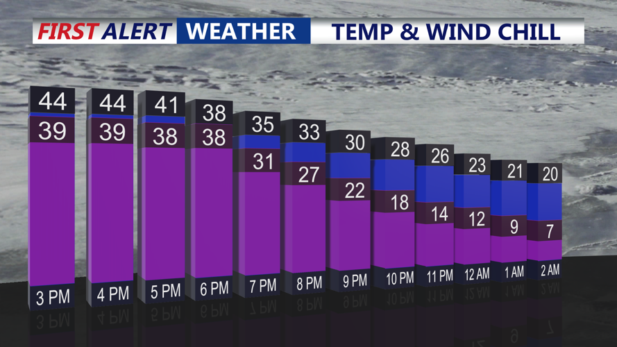
Saturday will bring partly cloudy skies with afternoon highs in the mid-40s. Conditions will shift quickly Saturday evening as a front moves through, sending temperatures plummeting overnight into the single digits and teens. Wind chills are expected to drop below zero in many areas.

Arctic front pushes through this evening, temperatures and wind chills crash into Saturday morning.
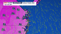
A Cold Weather Advisory is in effect from 12 a.m. Saturday until 10 a.m. Saturday, with wind chill values expected as low as 8 degrees below zero.

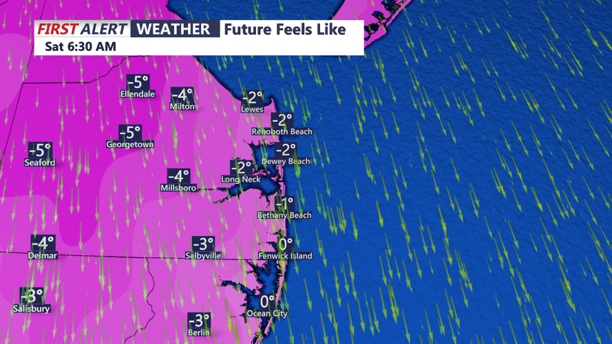
Feeling like -1 to -7 below zero Saturday morning.
Saturday will remain bitterly cold, with increasing cloud cover and highs only in the low 20s, setting the stage for a significant winter storm expected to impact Delmarva beginning Saturday night.
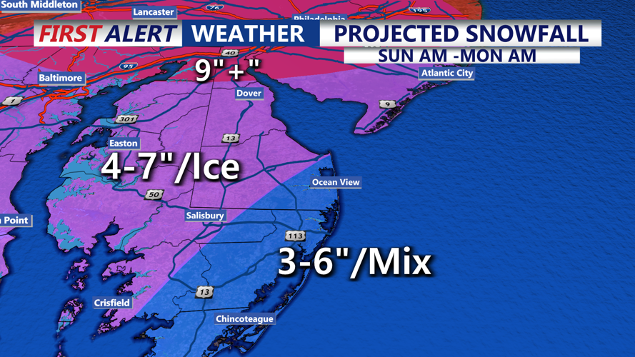
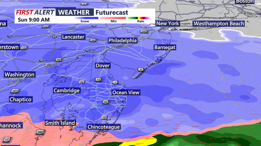
A major winter storm is forecast to move into the area Saturday night through early Monday afternoon, bringing significant impacts from accumulating snow, sleet and freezing rain. Precipitation is expected to spread into the region from southwest to northeast overnight Saturday night, beginning as all snow due to very cold air at the surface and throughout the atmosphere. As moisture deepens toward daybreak Sunday, snowfall may become moderate to heavy at times. Snowfall rates of 1-2 inches per hour Sunday morning.

Snowfall rates 1-2" per/HR for everyone Sunday morning.
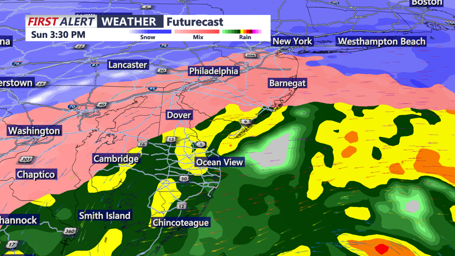
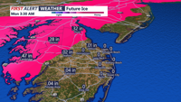
During the day Sunday, warmer air moving in aloft may create a “warm nose” in the atmosphere, allowing snow to mix with or change to sleet and freezing rain, especially across portions of the Eastern Shore and Mid-Shore of Maryland.

Warmer air filters in Sunday afternoon changing snow to rain at the coast, staying sleet/freezing rain into the Mid-Shore.
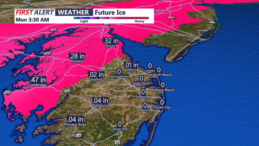
Sleet and freezing rain could reduce snow totals in some areas but create additional hazards, including slick travel and the potential for tree damage and power outages. Ice accretion over a quarter-inch is possible in parts of the Eastern Shore and Mid-Shore.

Ice accumulation is a growing concern on the Mid-Shore as heavy snow transitions to sleet and freezing rain Sunday afternoon-evening.
The Delmarva coast could also see a marine influence later Sunday, potentially causing precipitation to mix with or change to plain rain, though substantial snow is still expected before any changeover occurs.
Forecast snow totals currently range from 3 to 6 inches for much of the region, with mixing likely limiting totals in some areas. Along the Delaware coast and south toward Ocean City and Assateague, totals are projected around 2 to 5 inches.
As the storm begins to pull away Sunday night into early Monday, colder air is expected to filter back in, which may change precipitation back to all snow for most areas with additional accumulations possible.
A Winter Storm Watch remains in effect for the entire area from Saturday night through early Monday afternoon.
After the storm exits, arctic air will remain locked in across Delmarva into late next week. Temperatures are expected to stay below freezing across much of the area through Thursday, with many locations struggling to get out of the low 20s. Breezy conditions Monday and Tuesday will add to the danger, with wind chills likely dropping below zero areawide Monday and Tuesday night, and wind chills holding in the single digits during the day.
This prolonged stretch of cold could be dangerous for anyone spending extended time outdoors without proper clothing, and additional cold weather headlines may be needed next week.
Stay up to date on the approaching winter storm with radar and hourly forecasts in the CoastTV weather app, available for Apple and Android.
