


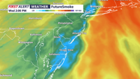
DELMARVA - It was a gorgeous Mother's Day across Delmarva, with abundant sunshine and temperatures in the upper 70s and lower 80s. A cold fron…
From
To

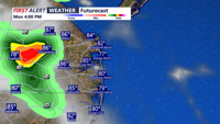
Much warmer Thursday with 70s, then a cold front bring rain and colder temperatures Friday into the weekend.

A Yellow Alert continues for rain, heavy at times into this evening.

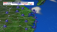
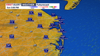
A few showers overnight with increasing winds, then windy and turning colder Sunday into early next week.

High pressure build into the region overnight into Saturday, with dry and cool weather. High pressure slides to the east on Sunday with breezy and warmer conditions.

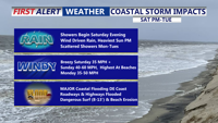
A period of relative calm continues this evening and tonight, before a significant coastal storm develops and impacts the region by late weekend.

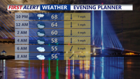
High pressure remains in control through this evening with temperatures in the 70s, then 60s this evening under partly cloudy skies.

Expect partly sunny skies into the afternoon hours, allowing temperatures to climb into the mid to upper 80s. As the day progresses, a cold front advancing from the west will bring increasing humidity and instability.

High pressure continues to drift off the east coast, bringing in warmer and more humid air to the Mid-Atlantic region.

We've seen a round of showers and storms to start our Friday, with more on the way this afternoon and possibly this evening. Highs in the 60s, and possibly 70s where the sun is out a bit longer.