





Delmarva enjoys another pleasant day today before a warm front brings increasing humidity and periods of rain and thunderstorms Thursday and Friday.
From
To


Delmarva is entering a prolonged stretch of hot and very humid weather that will continue through at least Tuesday. Daily chances for showers and thunderstorms will accompany the heat, with some storms capable of producing damaging wind gusts, torrential rainfall and localized flash flooding. A weak cold front Sunday may provide a brief break from the oppressive humidity before moisture surges back Monday and Tuesday. A stronger front could finally bring more noticeable relief by late Tuesday or Wednesday.


Hot and very humid weather will remain locked over Delmarva through Tuesday, with only a brief reduction in humidity expected Sunday. Thunderstorm chances will increase Friday and Saturday before returning early next week.


Sunshine, low humidity and comfortable temperatures will make Monday one of the nicest July days on Delmarva before heat and humidity build through midweek.

Heat and humidity return today as scattered storms bring a limited risk of damaging winds and localized flooding.


Showers and thunderstorms are expected to develop across Delmarva today, with damaging wind gusts and localized flash flooding the main concerns.


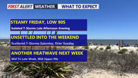
Delmarva will see a mostly sunny and seasonably warm day today, with inland highs in the mid 80s and cooler conditions along the coast. A slow-moving cold front will bring increasing chances for showers and thunderstorms late Friday into Saturday before drier weather returns Sunday. Heat and humidity are expected to build again by the middle and latter part of next week.


Delmarva will see a cloudy and humid day today as a warm front lifts north, bringing scattered showers and thunderstorms late this afternoon into tonight. A few storms could produce damaging wind gusts and heavy downpours. Dangerous heat and humidity build Thursday and Friday, with heat index values potentially reaching 95 to 104 degrees and additional severe storm chances.

Isolated showers or storms may arrive around dawn Wednesday before Sussex County sees a more unsettled, humid day with additional thunderstorm chances.


Sussex County will see rising temperatures and humidity through Friday, with dangerous heat and evening storm chances before relief arrives late Friday night.