


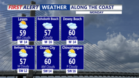
Mostly clear to partly cloudy overnight with temperatures dipping into the upper 30s and low 40s by Monday morning.
From
To

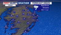
The chilly rain this afternoon will taper off late afternoon or early evening. Up to a quarter inch of rain is possible in some areas. Temperatures will be in the 40s and 50s.

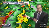
Meteorologist Chris Mastrobuono has the latest on a RED ALERT for a threat of damaging wind gusts in excess of 70 mph and isolated tornadoes t…

Delmarva dries out this afternoon after morning showers, with partly sunny skies, gusty southwest winds, and highs in the upper 40s to near 50. Tonight stays above freezing in the mid to upper 30s. A weak system brings a chance for light showers Thursday late afternoon through Thursday night, followed by a pleasant, partly cloudy Friday. The weekend looks outstanding, peaking Saturday with sunshine and highs in the upper 50s to near 60, then cooling a bit Sunday behind a backdoor cold front. Early next week bears watching for another system that could bring a wintry mix, but confidence is still low.

The dangerous cold stretch continues for Delmarva for the rest of the weekend and into the start of the new week.

Low clouds and patchy fog are possible late Tuesday evening into early Wednesday, then Sussex County turns sunnier and breezy with gusts near 30 mph.

More clouds than sun today and a bit milder, then windy and warmer start to week.

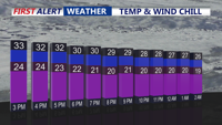
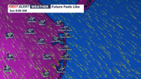
A cloudy and very cold Monday continues for Delmarva with temperatures in the 30s, and wind chills in the 20s.

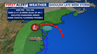
A low pressure system will form to the south of Delmarva, passing near or just to our west by Thursday night, pushing a cold front through the region.

A cold front will slide southeast through the region this evening, but it’s expected to pass without rain and with little added cloud cover. The main change will be a noticeable uptick in winds and a refreshing push of cooler air.