




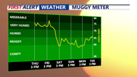
Sussex County will turn hot and humid Thursday, with another round of strong to severe thunderstorms possible later in the day.
From
To


Sussex County faces another chance for storms tonight before dangerous heat and a renewed severe weather threat develop Thursday.


Heat and humidity build Tuesday as Sussex County faces an increasing threat of severe thunderstorms and heavy rain.

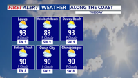
Sussex County turns hotter and more humid Tuesday with an increasing risk of strong to severe thunderstorms.


Code Red air quality will continue across Delmarva today as dense Canadian wildfire smoke lingers ahead of a stormy, hot and humid Saturday.


Showers and storms ending this evening, then clearing and drier air building into Delmarva the rest of the week.


Delmarva will stay hot, sunny and dry today as southwest winds continue to push early-season heat into the region. Georgetown could approach or break a daily record high, while Delaware beaches will remain cooler but breezy. A Code Orange Air Quality Alert is in effect for Delaware today through Wednesday, and there is a moderate risk of dangerous rip currents at Delaware beaches. One more very hot day is expected Wednesday before a cold front brings showers and thunderstorms, with isolated strong to severe storms possible. Cooler, unsettled weather is expected late week into Memorial Day weekend.


Morning showers, then a breezy and colder start to the week.


Morning showers Monday, then breezy and colder with afternoon sunshine.


Delmarva enjoys one more day of record-setting warmth today, with inland highs in the upper 70s to low 80s and cooler readings near the water. Gusty south winds, higher humidity, and increasing clouds will build through the afternoon before a threat for a few strong to severe storms develops this evening, mainly between 6 and 10 p.m. A strong cold front moves through late tonight into Thursday morning, bringing falling temperatures, gusty northwest winds, and much colder air to end the week.