


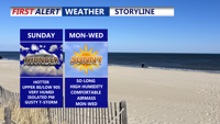
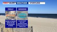
Delmarva will swelter under heat and humidity Sunday, with temperatures climbing into the upper 80s and low 90s, and heat index values reaching 100–104 degrees. A cold front moving through the region could trigger isolated strong to severe storms late in the day, though widespread storm activity remains limited. High pressure builds in early this week, bringing drier and more comfortable conditions through Wednesday before heat and humidity make a comeback toward the end of the week.
From
To

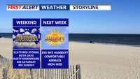
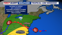
Delmarva will see scattered showers and storms this weekend, with the highest rain chances Saturday and a risk for stronger storms Sunday. Highs will reach the 80s and 90s before cooler, drier air moves in Sunday night. Early next week looks pleasant with sunshine and lower humidity, before warmer, stormier weather returns midweek.

Scattered showers and thunderstorms are expected from early Saturday through early Monday in Sussex County, with rising heat and humidity followed by a cold front bringing relief.

Spotty showers and a low threat for thunderstorms are forecast from late Friday into Saturday in Sussex County, with increasing rain chances and high humidity through the weekend.

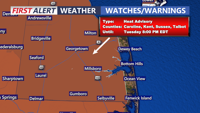
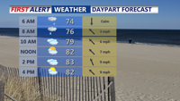
The summer sizzle is on this afternoon as temperatures soar into the mid 90s away from the coast, with heat index values as high as 106. Be careful in the heat and stay hydrated with water. A Heat Advisory is in effect into this evening.

From early Friday through early Sunday, Sussex County will experience waves of showers and possible thunderstorms with high humidity and a low-end flood threat.

A period of heat and humidity will give way to increasing rain chances and possible thunderstorms in Sussex County from late Thursday through early Saturday.

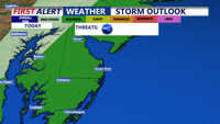
A cold front continues to push eastward from the Ohio Valley into the Delmarva this afternoon. Ahead of the front, scattered showers and storms develop later this afternoon and evening. A few storms could contain damaging winds and torrential rain.

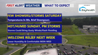
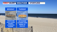
A damp and stormy weekend as unsettled weather takes hold. A weak cold front and associated low pressure system will bring widespread showers and possible thunderstorms Saturday, followed by another round Sunday afternoon with the arrival of a warm front. The Storm Prediction Center places Delmarva under a Marginal Risk for severe weather Saturday, with damaging winds as the main concern. Intermittent clearing arrives Monday before a fresh round of storms hits Tuesday.

A slow-moving weather system will bring showers and a slight risk of severe storms to Delmarva early in the week, with milder and partly sunny conditions expected by midweek. A cold front arrives late Wednesday into Thursday, ushering in cooler air and the chance of spotty showers. Temperatures will rebound slightly over the weekend as high pressure returns.